What to Expect During a Facade Survey: A Comprehensive Guide


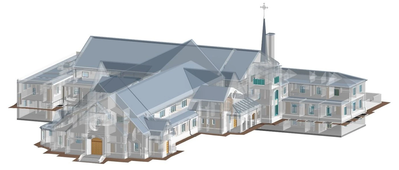
Existing Conditions recently surveyed a Boston University building at 270 Bay State Road in Boston. Despite some fog and clouds, the team successfully surveyed the exterior facade of the building for the client and delivered high-quality drone images, laser scan data, and accurate architectural as-built drawings. In this article, you will get an inside look at the process that Existing Conditions uses to holistically survey the exterior of a building. From the initial overview of the building and surrounding area to the completion of the drone flights and laser scanning, our team works thoroughly and thoughtfully to provide clients with high-quality information about their building.
For facade surveys and building envelope surveys, we typically 3D laser scan the exterior of the building and its immediate context, then use drone surveys to home in on specific areas of concern or importance. Our team captures both wide-angle and up-close drone images of our client’s building, which adds a photographic layer of detail to the laser-accurate architectural as-builts. Together, all the data collected will be pieced to create our final deliverable.

Exterior Rendering
The Process
Preparation and Preliminary Scans:
Before the team arrives on site, they communicate with the client to obtain necessary information about their building and the surrounding area. They will ask for any as=built building plans on file and any considerations they will need to take into account when surveying the building. This way, when the team from Existing Conditions arrives on-site, they have a plan as to how they will approach the site visit, and they are prepared for any challenges that may arise.
Once the team arrives on-site, they gather a general awareness of the entire building and the immediate surrounding area. They walk the property and ensure that the premises are safe for us to operate our 3D laser scanning equipment, and if needed, they will also enter the building and access the roof to gain a better vantage point of the facade. They also take preliminary drone imaging of the building’s facade. This consists of high-resolution photographs that include the buildings and structures in question, as well as surrounding buildings, to better contextualize the layout of the area. Later in the process, they capture long-range images which are used to create the drawings, but those images are separate from this preliminary long-range drone imaging. Having completed this initial survey of the building, the team now has situational awareness of the property, which they use to determine where to operate the 3D laser scanners and fly the drones. This process also helps to ensure that safety measures are taken to consider any possible obstacles or risks present on-site. Common challenges include building access and occupancy, as well as building hazards, such as structural deterioration.
3D Laser Scanning Process:
Our laser scanning process involves using construction-grade terrestrial LiDAR systems to collect detailed data about a given surface, building element, or structure. “LiDAR ” is similar to “Radar” in that it uses reflected light waves to measure distances, whereas radar uses reflected radio waves. In facade surveying, laser scanning allows any facade within the line of sight of the scanner to be measured and analyzed with high precision and accuracy. Existing Conditions uses a variety of Leica and NavVis scanners for their laser scanning purposes. The team is constantly testing new equipment to provide our clients with access to the best tools possible.
To begin the 3D laser scanning process, the team sets up the laser scanning equipment and connects it to an associated app on the tablet. Existing Conditions plans out the different locations from which they need to scan so that they can “stitch” together the data and begin to create a digital version of the building. At each scan location, they make sure the scan is clean and not obstructed by trees, lampposts, or other possible obstructions. For example, the field technician for the Bay State building had to adjust the placement of the scanner to avoid some tree limbs which were obtrusive to the scanner’s line of sight. If there were areas with overgrown vegetation or parts of the facade that required extra attention, they captured multiple 3D laser scans to get the data they needed. If the team was concerned that a particular scan did not capture everything they intended, they could check the app on the tablet to confirm the accuracy of their scans. As each 3D laser scan was performed, Existing Conditions could view and optimize that data on the tablet, ensuring that the site work was captured properly and efficiently without the need for future site visits.
As the team moved the 3D laser scanner around the building along the “stitch” path, they continue to capture different vantage points so that the final set of data reflects a comprehensive scan of the building. Each scan takes about two minutes, after which the team moves to the next spot and begins the next scan.
At 270 Bay State Road, the team took 50 different 3D laser scans as they circumnavigated the entire building. In total, the laser scanning process took about six hours to complete. Once the scan data was collected, it was processed and used to create detailed exterior facade drawings for our clients.

Exterior Rendering
Drone Imaging Process:
To capture photographic data of a building from an aerial perspective, our team uses drones. To start, our licensed pilot will prepare the drone by connecting the mobile controller to monitor the camera of the drone. This is the pilot’s eye in the sky. When the pilot is ready and the drone is set up, they take flight and begin the survey. Typically, starting with large-scale, wide-frame imaging allows the pilot to get a better sense of the project at hand. Similar to the preliminary walk around the building, the pilot will begin the official imaging process from hundreds of feet away to gain as much perspective as possible. From there, they systematically collect detailed data on the most critical areas. Often, this systematic approach requires focusing on the discolored, rusted, chipped, and deteriorated sections of the building. At the end of the day, Existing Conditions will have captured the data we need and scanned the property to completion. The team is then ready to land the drone and prepare for data processing and analysis.
External Factors:
While Existing Conditions is trained to make operations smooth and concise, external considerations often creep into the scene. One of the most impactful external factors in any outdoor surveying operation is the weather. If it is raining heavily or snowing, we typically postpone our surveying to protect our high-level equipment from potential water damage. However, foggy or cloudy weather does not prevent us from 3D laser scanning. These conditions cause low visibility, and we might not even be able to see our drone. The drone’s GPS allows us to know exactly where the drone is, even if we cannot see it from the ground. For example, at 270 Bay State Road, the team had to navigate fog and wind while surveying the building. Antonio Cue of the Existing Conditions marketing team was spectating on site, and he reported that “the fog was an obstacle, but mostly for drone picture quality.” Additionally, Cue noted another important factor that the drone team had to consider – pigeons. “The pigeons on the roof of the building would get excited by the drone and fly around it closely,” Cue recalled. Our team has experience dealing with all types of externalities, including falcons, pigeons, weather, and much more. As such, they were prepared for these challenges at 270 Bay State, and they successfully captured the building data without disruption.
Next Steps:
After a hard day's work, the flight and surveying team sent the data out to be processed, cleaned, and then further analyzed. Data processing is a skilled, labor-intensive process in which our team works hard to create the most practical, accurate deliverables for our clients. First, we must omit any obstructions or anomalies in the images, such as trees, vines, or surrounding buildings. Then, we input our data into the corresponding software program (e.g., Drone Deploy for drone images) to produce 3D drawings. Once we have created our initial drawings, there is further processing and reviewing must be done. Interestingly, it is very difficult to build a perfect right angle in real life. As a result, the drawings that our software generates from our reality capture are often not perfectly orthogonal, which makes them appear less neat. To provide the most professional, practical deliverable for our client, we amend our drawings to ensure they have exact right angles, without compromising their accuracy and precision.
After processing the data in our various software, we are ready to deliver the final product to our client. We often set up a meeting with our clients so that we can present our drawings to them and ensure that they are satisfied with the result. After this meeting, our client may contact us at any time in the future to follow up on our deliverables or request new drawings.


Existing Conditions’ Drone Services
Existing Conditions’ Drone Services provide fast and accurate drone video, imagery, and mapping, for architecture, engineering, and construction projects. With high-resolution cameras and LiDAR sensors, our drones capture video and images of buildings, sites, and infrastructure, facilitating real-time collaboration and decision-making.
Drones provide instant and updated site documentation, so that clients can get accurate data to make decisions and approve next steps. They are a safe, cost-effective tool for as-built reality capture, remote inspections, and project monitoring. By integrating drone services with 3D laser scanning, clients can receive detailed 2D maps and 3D models that enhance project planning and execution.
Existing Conditions 3D Laser Scanning Services
Over the past 27 years, we have measured, documented, and modeled over 10,000 buildings spanning over 700 million square feet across the United States, establishing ourselves as an industry leader in 3D laser scanning. Architects, builders, engineers, developers, facility managers, trust us to deliver digital representations of the as-built environment with unparalleled accuracy and efficiency. Our dedicated Project Managers provide fast and accurate 3D laser scanning services and drone imagery services, and expert CAD and BIM technicians create custom, detailed deliverables. Our greatest reward remains delivering superior-quality scan-to-BIM work and knowing we played a vital role in our clients’ unique and historic projects.
FAQs
How Does Laser Scanning Work?
.svg)
One primary method is that a laser scanner sends light pulses at high speeds which reflect off objects and return to the scanners’ sensor. For each pulse, the distance between the scanner and object is measured by determining the elapsed time between the sent and received pulses. Each point of the scan will be converted to a pixel with a known x-, y-, and z- coordinate. Laser scans or LiDAR scans are taken in multiple positions around a site from varying viewpoints. Millions of data points are captured and processed into a point cloud, creating an accurate data set of the structure or site.
What is a Drone Survey?
A drone survey, also known as aerial surveying or drone mapping, is the use of an unmanned aerial vehicle (UAV) to collect data from the air to create maps and models. Drones are equipped with cameras and sensors to capture high-resolution images and other data. The data is then processed to create detailed maps and models of the area being surveyed.
Related Articles