

3D Laser Scanning MEP Systems Creates Digital As-Builts for Design and Clash Detection
For an engineer managing MEP projects, precision and coordination are imperative. The key to successful MEP design, fabrication, and installation is knowing existing site conditions. Reality capture with 3D laser scanning makes that possible.
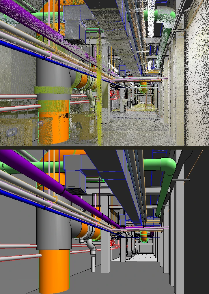
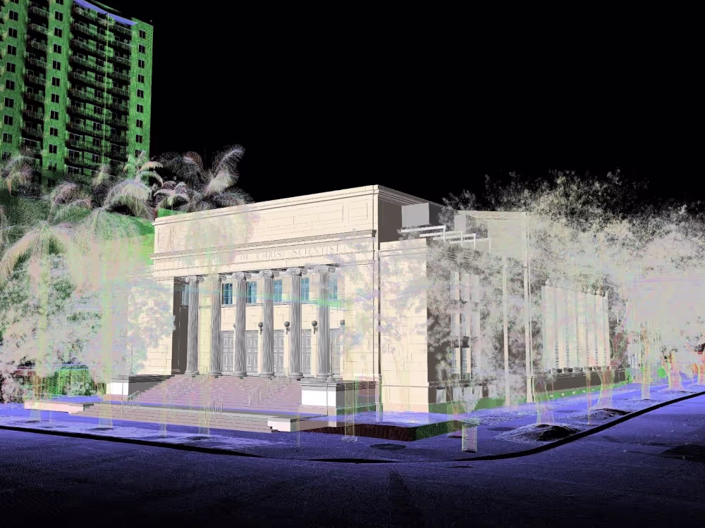
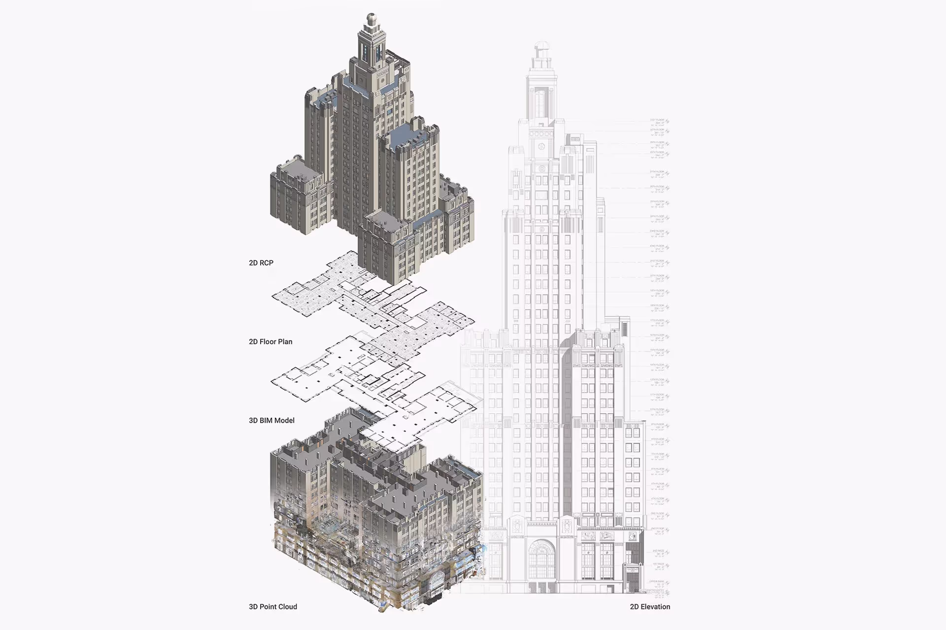
With a single 3D laser scan, over 2 million site dimensions are captured with 2-4mm accuracy in a point cloud, providing the data needed to create field-verified CAD drawings and BIM models. These deliverables help MEP engineers design HVAC layouts, plan electrical runs, and route plumbing systems with confidence. Plus, they help improve spatial planning, avoid clashes, and streamline installation.
Existing Conditions 3D Laser Scanning Services, Scan-to-CAD Services, and Scan-to-BIM Services help clients to:
- Digitally capture exact MEP/FP and HVAC system dimensions, layouts, and locations
- Visualize spatial relationships and integrate new designs
- Ensure modifications can be tied into existing systems
- Identify clashes to prevent costly rework
- Prefabricate new components and install with confidence
- Verify installation meets design specifications
- Document construction progress over time
.avif)
Expedite Your MEP Project with 3D Laser Scanning


Reasons to Use 3D Laser Scanning for MEP As-Built Documentation
Millimeter‑Level Accuracy
Terrestrial laser scanning and LiDAR technology deliver ±2–4mm accuracy, eliminating measurement errors that cost contractors an average of $5,000–$50,000 per conflict. High‑resolution point clouds provide 360° dimensions of pipe diameters, conduit runs, duct dimensions, and equipment clearances with unprecedented detail.
Reduced Field Time & Project Duration
Comprehensive MEP documentation is completed in 70% less time compared to traditional manual methods. A typical 50,000‑square‑foot facility can be 3D laser scanned in one day versus 2–3 weeks of manual measurement, accelerating project schedules and significantly reducing labor costs.
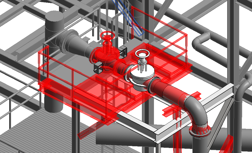
Advanced Clash Detection & Coordination
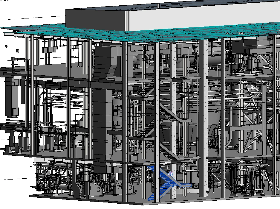
Spatial conflicts between MEP systems, structural elements, and architectural features are identified before fabrication. 3D BIM models enable design planning in a virtual environment, preventing costly field modifications that average $2,000–$10,000 per clash.
Cost Reduction
Accurate as‑built data minimizes change orders, rework, and material waste. Projects using 3D laser scanning report 50% fewer change orders and overall cost savings of 5–15%.
Comprehensive CAD & BIM Integration
Scan data is seamlessly integrated into Revit, AutoCAD, and other CAD and BIM platforms. The GPRS Mapping and Modeling Team delivers precise CAD drawings and 3D BIM models tailored to project standards, templates, and naming conventions, ensuring consistency and accuracy across every deliverable.
Ongoing Facility Management
A permanent digital record of the facility’s MEP infrastructure supports lifecycle management. Point cloud data and BIM models enable preventive maintenance, system upgrades, space planning, energy analysis, and regulatory compliance throughout the building’s operational life.
MEP 3D Laser Scanning Applications & Use Cases
New Construction & Build Outs
.svg)
Renovation & Retrofit Projects
Facility Management & Operations
Industrial & Manufacturing
Data Centers & Tech Facilities
Healthcare & Pharmaceutical
MEP 3D Laser Scanning Applications & Use Cases
New Construction & Build Outs
Renovation & Retrofit Projects
Facility Management & Operations
Industrial & Manufacturing
Data Centers & Tech Facilities

Start Accurate. Stay Accurate.

Trusted Partner
Expert Team

Comprehensive Data Capture

As-Built Drawings & 3D BIM Models
Industries We Serve

Architecture
Informed design starts with verified conditions, accurate spatial data, and coordinated BIM — so you can focus on what you do best: eliminate site uncertainty, speed up timelines, and skip manual measurements.

Construction
Operational efficiency through accurate as-builts, reduced downtime, and smarter asset tracking, paired with ongoing management via digital twins, up-to-date facility data, and fewer costly site visits.

Facilities Management
Boost operational efficiency with accurate as-builts, minimized downtime, and smarter asset planning and support ongoing management with digital twins, up-to-date data, and fewer costly site visits.

Engineering
Quality design through precise as-builts, advanced analysis, and tighter tolerances protect your reputation by delivering accurate BIM models that keep projects on time, on budget, and safe.

Real Estate
Stay on time with accurate documentation, rapid data capture, and efficient coordination - stay on budget by reducing rework, repeat visits, and improving cost and schedule accuracy with trusted data.

Entertainment
Production planning made easy with millimeter-accurate scans, verified as-builts, and precise coordination, enhanced by training and simulation using VR, real-world environments, and laser-accurate spatial data.

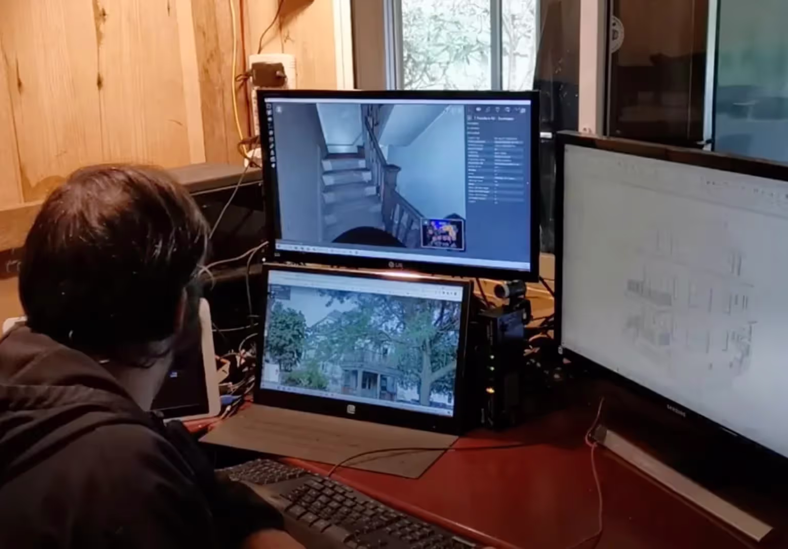
Our 3D Laser Scanning Process


.jpg)
Articles
%20for%20an%20industrial%20facility.webp)


3D Laser Scanning: Key Applications for Construction
Case Studies
-1%20(1).webp)

The Johns Hopkins Hospital

New York Life Building 51 Madison Avenue
Frequently Asked Questions
How Long Does It Take to 3D Laser Scan a Building and Deliver MEP Documentation?
Scan duration depends on building size and complexity. A typical 50,000 sq ft facility with moderate MEP complexity requires 1-2 days of field scanning. Point cloud processing and registration takes 2-3 days, and detailed BIM modeling to LOD 300-400 standards typically requires 2-4 weeks depending on system complexity and level of detail required. Rush services are available for critical path projects. Compared to traditional documentation methods which can take 3-8 weeks for the same facility, laser scanning reduces overall timeline by 50-70%. We provide preliminary point cloud data within 48 hours of scanning for immediate project needs, with final deliverables following your project schedule and priority requirements.
What is 3D Laser Scanning for MEP Systems and How Does it Work?
3D laser scanning for MEP (Mechanical, Electrical, Plumbing) systems uses LiDAR (Light Detection and Ranging) technology to capture millions of precise measurements of existing building infrastructure. A laser scanner emits pulses of light that bounce off surfaces and return to the sensor, calculating distances with ±2-4mm accuracy. This creates a detailed point cloud, a digital 3D representation of all visible MEP components including ductwork, piping, conduit, equipment, and structural elements. The point cloud is then processed and converted into accurate 2D CAD drawings and 3D BIM models for design coordination, clash detection, and construction planning.
Can Laser Scanning Detect Hidden MEP Systems Behind Walls or Above Ceilings?
3D laser scanning captures only visible surfaces using light-based technology and cannot penetrate walls, ceilings, or floors to detect hidden infrastructure. However, scanning provides significant value for MEP projects by documenting all accessible areas including open ceilings, mechanical rooms, roof equipment, and exposed systems in renovation areas.
What Industries Benefit from MEP Laser Scanning?
MEP laser scanning provides critical value across multiple sectors: Healthcare facilities (hospitals, surgical centers, laboratories) require precise documentation of medical gas systems, specialized HVAC, and infection control zones; Industrial and manufacturing plants need accurate process piping, material handling systems, and utility distribution mapping; Data centers and technology facilities benefit from detailed power distribution, cooling infrastructure, and cable routing documentation; Educational institutions, government buildings, and commercial offices use scanning for renovation planning and system upgrades; Historic buildings and adaptive reuse projects rely on scanning to understand existing conditions without invasive investigation; Pharmaceutical and clean room facilities require exact ceiling space coordination for critical environmental control systems. Any project with complex MEP systems, tight coordination requirements, congested spaces, or aggressive schedules benefits significantly from laser scanning technology.
How Accurate is the Point Cloud and BIM Model?
Point clouds are a digital representation of spatial information, stored as a collection of points with three spatial coordinates. They are millimeter-accurate and are scanned in the level of detail required for your project. BIM model features are created to your project-specific scope, LOD specifications can vary throughout the model. By specifying scope and project details, BIM models can be customized to your project.
Why is a Point Cloud Important?
Point clouds provide powerful and dynamic information for a project. By representing spatial data as a collection of coordinates, point clouds deliver large datasets that can be mined for information. The visualization and analysis from this data is invaluable for decision making. Our Product team transforms point clouds into customized drawings and models used for visualization, analysis, design, construction, renovation, prefabrication, and facility modifications.


