

Contour Mapping Explained

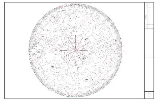
Contour mapping is the process of making a two-dimensional representation of elevation changes on a floor or surface from a birds-eye view, known as a contour map or deformation map. Interconnected lines of various shapes depict points on the map that are at equal height or elevation. These lines are known as contour lines.
The distance between contour lines measures an area’s slope. This measurement shows how steep certain parts of the job site or terrain are. When the lines are widely spaced, that indicates a gradual slope, while tightly spaced lines represent a very steep slope.
In the modern landscape of AEC industries, LiDAR-based laser scanners have completely revolutionized how professionals perform projects. Contour mapping is one of the many deliverables that reality capture professionals, like our Project Managers, can provide. With millimeter-accurate scan data from modern 3D laser scanners, contour mapping is now more precise and compatible with AEC projects.
Applications and Benefits of Contour Mapping
From the design phase to post-construction, the capabilities of contour mapping can have a huge impact on the workflow of your next job.
Like all other reality capture deliverables, contour mapping provides the client with a unique and detailed visual of their project. As previously mentioned, contour maps showcase the changes in elevation from an aerial view that would be nearly impossible to discern solely with the human eye. The data is also captured and delivered in a fraction of the time traditional methods would take.
One way contour mapping has influenced AEC industries is by providing pre and post-pour analysis for concrete-pouring jobs.
When pouring concrete, it is important to understand the current conditions of the area, so the workers can plan accordingly. Reality capture scans can take place before the pour to give the client pre-pour asset documentation. This provides clients with a precise digital representation of the area and can help reveal any obstructions or uneven terrain.
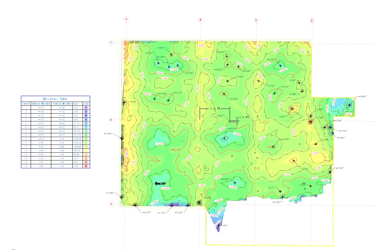
To properly analyze the site, the client must establish a level plane as the “zero” area on the contour map. Anything above that level displays as positive and requires grinding down or removal. Anything that is below the zero level is the area that will be filled in. This is known as “cut and fill” operations.
With this data, they can calculate the exact volume of concrete required to avoid over- and under-pouring. Scans can also be conducted once the pour is complete. The updated contour map helps ensure the pour is compliant with the design and contract requirements while also checking for any deformities in the slab.
The same can be done for cut and fill operations that use soil instead of concrete. This is done during the architectural design process to ensure structural stability and functionality of the building site. Cut and fill operations are useful when creating flat areas on sloped sites, so contour maps are vital to confirm what needs to be cut and filled. Workers cut by removing soil from higher elevations to lower areas, and they fill by adding soil to lower areas, thus creating level platforms.
Cut and fill operations are one example of how contour mapping is crucial for site analysis and planning. Contour maps can show the tiniest details required to properly assess a potential building location. At first glance, an area could look perfect, while further investigation using contour mapping could reveal weak spots and slopes in the ground.
Contour mapping can also reduce any red tape that would slow down or halt construction projects. It is important to understand environmental impacts, zoning codes, urban planning, and drainage rules so the project can progress without delay from higher authorities or malpractice. This is especially important for Environmental Impact Assessments (EIA), which evaluate the possible environmental risks of proposed projects. Contour maps provide project developers, municipal offices, and expert consultants with all the information needed to progress safely with the building plan. The same can be done post-construction when adding new equipment or other additions to the facility.
Thank you for reading this excerpt. Read the full article to learn more about contour mapping.


