Innovations in the Sky: New Technology in Facade Surveying

.avif)
Innovations in the Sky: New Technology in Facade Surveying
Aerial imaging is not a recent invention. French photographer Gaspard-Félix Tournachon captured images above Paris in 1858. His mechanism of flight: balloons. The use of aerial images caught traction, speeding worldwide in only two years. In 1860, photographer James Black captured a bird’s-eye-view of Boston. Aerial imaging didn’t stop there.

Since then, the technology we use to capture images from the air has changed and improved substantially. Facade surveying can benefit architects, builders, and commercial real estate professionals in many ways. The first way is that it can help to identify any potential structural issues that may be present in a building's facade. This can include cracks, bulges, moisture, or other signs of damage that could indicate a problem with the building's foundation or structure. By identifying potential structural issues early on, facade surveying can also help to improve building safety. This can help prevent accidents, injuries, or even fatalities that could occur as a result of a building collapse or other structural failure.
The following technology has played a significant role in improving facade surveying:
- Drones: Drones can be used to capture high dynamic range (HDR) images in photo, video, and panorama modes.
- Thermal Imaging: Thermal imaging technology can be used to detect variations in temperature across a building's facade. This can be useful for identifying areas where there may be air leaks or other forms of energy loss.
- DroneDeploy: DroneDeploy can streamline and automate the drone surveying process, allowing for faster and more efficient data collection and analysis.
- Laser Scanning: Laser scanning technology can be used to create a detailed 3D model of a building's facade. 3D point clouds are incredibly valuable because they comprise a set of XYZ coordinates in digital space.
- Artificial Intelligence (AI): AI technology can be used to analyze large amounts of data collected during facade surveying.
For over 27 years, Existing Conditions has used the newest, most advanced equipment to provide our clients with high quality documentation of their buildings. Our facade surveying techniques benefit our clients because it saves time, reduces cost, and improve safety. For example, facade surveying can save time by providing a comprehensive and accurate assessment of a building's exterior, which can help identify issues more quickly and efficiently than traditional methods. Another example is that facade surveying can save costs by identifying potential issues or defects in the building facade before they become more severe and expensive to repair. Lastly, facade surveying can improve safety by identifying potential hazards or defects in the building facade that could pose a risk to occupants, pedestrians, or neighboring properties. We have created maps of physical structures using construction-grade 3D laser scanning, innovative drone imaging, and versatile software programs. Our equipment is state-of-the-art, and every year we invest in new technology to ensure that we are providing our clients with the highest-quality existing conditions surveys. In this article, we will take a closer look at up-and-coming technology that could revolutionize the way we conduct facade surveys in the next ten years.
To take a deeper dive into the use of technology in facade surveying and earn free AIA credit, make sure to watch the "Push the Envelope: How to Leverage Technology to Evaluate Building Enclosures" webinar by Existing Conditions today. You'll learn how advanced facade surveying techniques can improve your building enclosure evaluations and gain valuable insights into the benefits of leveraging technology in this field. Don't miss out on this opportunity to enhance your knowledge and earn free AIA credit!
The benefits of conducting facade surveys are significant, as they enable our clients to save time and money and enhance safety, thereby adding substantial value to their operations. We can elevate your next project with our facade surveying techniques - contact us today for more information.
Our Drone Fleet
The use of drones to survey buildings and structures has expanded in the last twenty years, and these recent developments have allowed people to see buildings from new perspectives. The DJI Mavic Air 2 is Existing Conditions' most frequently deployed drone. This state-of-the-art drone is an excellent choice for conducting basic building surveys. It boasts an impressive battery life of 30 minutes and is capable of capturing high dynamic range (HDR) images in photo, video, and panorama modes. These are significant enhancements compared to earlier models. It has a long-lasting, durable camera that captures incredible color and brightness.
The application of drones may have special significance in the coming years. Laws in New York City, for instance, mandate that building owners have a facade inspection every five years. Currently, Local Law 11 demands physical inspection using scaffolding in New York City. Despite this, there is a bright future ahead. One example of how Existing Conditions’ facade surveying services have helped our clients in the past is our project at 270 Bay State Road. Located on a college campus, this occupied building presented a unique challenge. Instead of our client opting for the time-consuming process of covering the entire property with scaffolding, which would have taken two weeks, they turned to Existing Conditions for a more efficient solution.

Our team utilized a drone for data collection, enabling us to capture the necessary information within just two hours. In certain areas of the building where delicate sod and plant material were present, traditional lifts posed a risk of damaging the soil and surrounding vegetation, resulting in costly repairs and delays. Additionally, the narrow walkway with soft scapes on each side presented challenges for maneuvering a traditional lift. However, by utilizing a drone for data collection, we were able to avoid these issues and ensure the preservation of the delicate vegetation and walkway, saving time and costs associated with potential damages. Additionally, scaffolding would be time-consuming and pose safety concerns in an active building such as a college campus like this, where students are constantly walking through.
The drone can also provide a bird's eye view of the area, capturing minute details that may not be visible from the ground, such as the tops of roofs and window sills. The high-resolution imagery obtained from the drone can be used to create accurate and comprehensive documentation, which was delivered to our client within a 24-hour turnaround time. Overall, the use of drones for data capture in this scenario has proven to be a time-saving and cost-effective choice, allowing for efficient and safe data collection in a complex environment.
Leveraging Existing Conditions' technology reduces the risks associated with exterior renovations and allows you to work without scaffolding or other disruptions for your occupants. Seeing as drones are a quick and accurate way of completing facade surveys, the acceptance of drones for Local Law 11 may increase soon. The city has recently been exploring how to increase the usage of drones in exterior surveying.
These advances in drone hardware have been accompanied by new and improved software programs that allow us to process drone images with higher accuracy and efficiency. Existing Conditions uses several software and modeling technologies, including 2D CAD, which allows us to analyze and map drone and laser scanner data. New software, such as DroneDeploy and thermographic imaging, are penetrating the industry.
Drone Thermographic Imaging
New technology allows drone footage to capture thermographic data rather than dimensional data. The use of software like this can be game-changing for understanding thermal and energy distribution in your building. More often than ever, Existing Conditions is utilizing drones like the DJI Matrice 300 RTK that can capture thermographic data. This request is rising fast as building owners realize they can cut down on unnecessary costs by evaluating the heat and energy distributions in their buildings. Thermal imaging has been improving the safety of the industrial and energy sectors for years; bringing this data to the sky will catapult progress further. The primary applications of thermal imaging in drone surveys are improving safety and efficiency at construction sites, “bridge infrastructure, power lines, wind turbines, solar farms, roof and pipeline inspections, and more.” The bottom line: thermal drone imaging is saving lives.
One relevant distinction in thermographic imagers lies within their post-production capabilities. Existing Conditions’ surveying teams pay careful attention to the radiometric vs. non-radiometric quality of a thermal camera. Radiometric thermal cameras allow for post-production analysis and editing since the thermogram creates a pixelated thermal image. Within each pixel, there are measured values such as “emissivity, distance from the object, reflected temperature, and humidity.” On the other hand, non-radiometric thermal cameras do not have the same post-production capability. They produce a thermal field, which measures temperature gradients, without any post-evaluation capabilities.

DroneDeploy
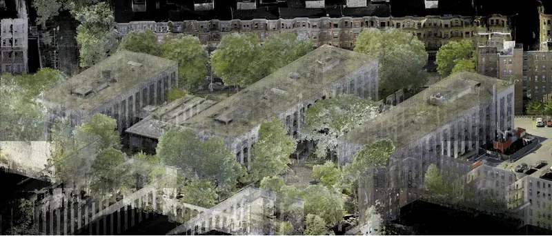
Another breakthrough platform for facade surveying is a piece of software called DroneDeploy. DroneDeploy has recently entered the cloud software market for drone imaging, and it makes aerial data more accessible and productive for users. The app facilitates drone flight by converting your mobile device into a flight controller. Recently, the software has made significant improvements in its modeling capabilities. DroneDeploy now offers high-quality 2D orthomosaic modeling. Orthomosaic modeling provides users with a birds-eye view, similar to Google Earth. However, DroneDeploy’s program produces far higher-quality images than Google Earth, as well as most other drone imaging software. Having a birds-eye, mosaic view of your entire property is an invaluable resource for a building owner. Additionally, DroneDeploy can generate 3D ‘dollhouse’ models. At Existing Conditions, we use these dollhouse models frequently to help our clients understand and perceive the entirety of their building. We can look in depth at every crevice or crack in the facade, and see the whole property in three-dimensional space. After all is said and done, DroneDeploy helps Existing Conditions export data hassle-free to more advanced processing software, both in the form of 2D orthomosaics and 3D dollhouse models.

Arctec Eva Handheld Scanner
In addition to these innovations in drone capture, Arctec 3D’s Arctec Eva 3D Scanner is another technology on the horizon in facade surveying. This scanner is one of the fastest handheld 3D scanners on the market, and it provides up to 0.1mm accuracy. It leverages advanced AI to produce accurate models and capture textured, precise measurements of objects in a small amount of time. It is used in many different industries, including healthcare, reverse engineering, and industrial design and manufacturing. At Existing Conditions, we have used this product to collect up-close, highly accurate models of our clients' facades. The scanner captures a much more detailed image of the facade than a laser scanner or drone. Arctec also provides users with software that allows several scanners to be bundled and synced together to capture larger objects, such as facades. However, handheld scanners still require more time and labor, and scaffolding must be set up to reach the upper sections of a facade.
Currently, cost and efficiency are some of the primary reasons why these handheld scanners are not used more often in facade surveying today. In the future, as manufacturing costs lower and the scanners can model and measure larger areas in less time, these scanners could revolutionize the accuracy with which we can conduct facade surveys. They could also be applied to facade inspections, which are required in many large cities (such as New York City, under Local Law 11).


Leica ScanStation P50
A final innovation in scanning technology is the newest long range terrestrial laser scanner by Leica Geosystems, the Leica ScanStation P50. The P50 is the fastest scanner on the market, and it has a scanning range of about 1 km. Other long-range scanners with smaller ranges often must be set up in inaccessible, potentially unsafe locations, such as a small roof area or even a ledge. In contrast, due to its long-range, the P50 allows professionals to set up the scanner in safer locations farther away from the building being scanned, such as more accessible roofs of nearby buildings. Additionally, the P50’s long-range increases safety without sacrificing accuracy. Users can transform the data they capture into survey-grade maps of their building in realistic clarity. The P50 performs under extreme temperatures ranging from -20oC to 50oC and is dust and water-resistant. Using the P50 scanner, Existing Conditions provides our clients with high-quality drawings and 3D models which can be used for countless building purposes.

Bringing it All Together
These innovative technologies sit at the forefront of their respective fields, and they are introducing new ideas and capabilities into standard operating procedures. In drone surveying, innovations in both hardware and software are allowing users to generate more accurate, useful, and efficient 3D drawings, as well as thermographic imaging. The handheld Arctec Eva 3D Scanner is providing surveyors with extremely accurate, detailed models of small objects or sections of facade. The Leica P50 is revolutionizing the laser scanning industry with its long range and superior accuracy.
For over 27 years, Existing Conditions has stayed ahead of the curve and kept up with the newest innovative technologies in the architectural surveying industry. Many other innovations could impact the facade surveying industry in the future. Existing Conditions will continue to leverage the optimal equipment and software available to us to provide our clients with high-quality, accurate drawings of their most valuable assets. Contact us today to gain the situational awareness you need when you need it, learn more about up-and-coming surveying technologies, and discover how Existing Conditions can help your business save time and resources.
Existing Conditions 3D Laser Scanning Services
Over the past 27 years, we have measured, documented, and modeled over 10,000 buildings spanning over 700 million square feet across the United States, establishing ourselves as an industry leader in 3D laser scanning. Architects, builders, engineers, developers, facility managers, trust us to deliver digital representations of the as-built environment with unparalleled accuracy and efficiency. Our dedicated Project Managers provide fast and accurate 3D laser scanning services and drone imagery services, and expert CAD and BIM technicians create custom, detailed deliverables. Our greatest reward remains delivering superior-quality scan-to-BIM work and knowing we played a vital role in our clients’ unique and historic projects.
FAQs
How Does Laser Scanning Work?
.svg)
One primary method is that a laser scanner sends light pulses at high speeds which reflect off objects and return to the scanners’ sensor. For each pulse, the distance between the scanner and object is measured by determining the elapsed time between the sent and received pulses. Each point of the scan will be converted to a pixel with a known x-, y-, and z- coordinate. Laser scans or LiDAR scans are taken in multiple positions around a site from varying viewpoints. Millions of data points are captured and processed into a point cloud, creating an accurate data set of the structure or site.
What are the Benefits of 3D Laser Scanning?
3D laser scanning captures millions of 3D data points per second for each scan location, providing incredibly rich data of a building or project site. Sites are captured in high detail the first time, eliminating disruption and the need for return visits. Datasets are dimensionally accurate, measurable and shareable, expediting project planning and execution. Accurate design plans are produced from the start expediting field work and reducing change orders, delays and costs. Communication is improved, teams can discuss plans while each has access to the same information, creating a more dynamic working environment.
What is a Drone Survey?
A drone survey, also known as aerial surveying or drone mapping, is the use of an unmanned aerial vehicle (UAV) to collect data from the air to create maps and models. Drones are equipped with cameras and sensors to capture high-resolution images and other data. The data is then processed to create detailed maps and models of the area being surveyed.