RTK vs Total Stations: What They Do and When to Use Them

Real-Time Kinematic (RTK) positioning and total stations are both used for surveying purposes, like the creation of survey control points for reality capture scans. Both are used by licensed land surveyors and engineers for Subsurface Utility Engineering surveys (SUE) to determine accurate positions on the Earth’s surface. However, they differ in how they operate, so understanding these differences is crucial when selecting the right tool for a given project.
Before proceeding, it is important to note that GPRS does not conduct Land Surveys or Subsurface Utility Engineering Surveys (SUE). Our work, however, can support both sets of professionals by providing SUE level B utility locating and mapping quality. And, in the case of reality capture via LiDAR 3D laser scans, our average rate of accuracy is between 2 and 6 mm.
What is an RTK?
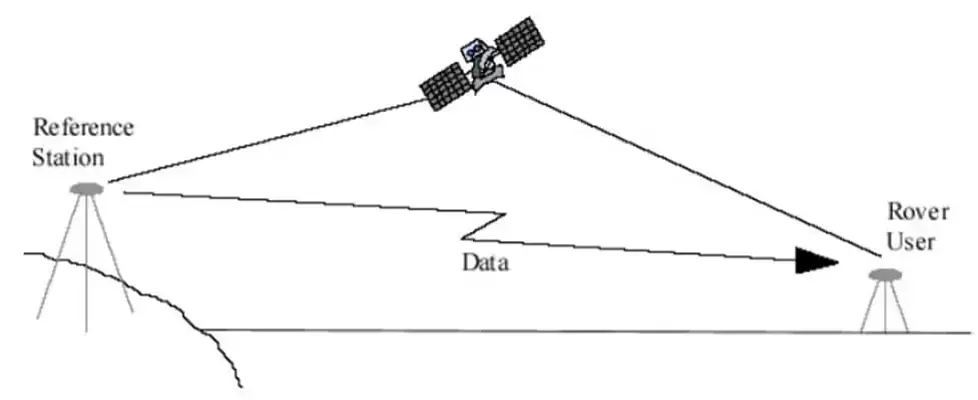
RTK is a protocol that utilizes existing GNSS (global navigation satellite system) technology to provide accurate geolocation within centimeters in some conditions.
In collaboration with satellite signals, it uses a fixed reference station and a mobile receiver, or rover, operated by the surveyor. The reference station receives signals from the satellites and computes any errors in measurements. From there, the base sends the real-time data to the rover to update the position computations and achieve an outstanding level of accuracy.
Advantages & Disadvantages of RTK
RTK geolocation provide surveyors with immediate feedback and 1-3 centimeter accuracy in best conditions. The level of precision and speed that can be attained using RTK exceeds what standard GPS devices can produce and leads to faster project completions. GPS accuracy typically ranges from 5 to 10 meters, or 500 to 1,000 centimeters.
However, the results of RTK require a clear view of the sky (line of sight), so it can connect to the existing GNSS. Without a strong signal to the satellite, the potential for multipath errors goes up. Multipath errors occur when a GNSS signal reflects off a surface before it reached the receiver. Because of this, areas with tall buildings or trees do not yield the best possible results.
RTK software also gives surveyors the option to use multiple, interconnected reference stations to perform large-scale surveying and mapping projects. RTK systems generally can maintain their accuracy in areas as large as 20 kilometers.
While this can be ideal for operations that span a wide area, it is still important to consider the previously mentioned obstacles surveyors may face.
What is a Total Station?
A total station is a surveying device that combines an electronic theodolite and an electronic distance meter (EDM). A theodolite measures angles with an internal magnifying optical system and the EDM uses electromagnetic waves to measure distances. By combining these tools, precise coordinates can be calculated and stored for future reference.
Along with land surveying, total stations can be used in other fields like engineering, construction, and 3D modeling.
.webp)
Advantages & Disadvantages of Total Stations
Total stations can provide surveyors with highly precise results under the right circumstances. Using the EDM, total stations are capable of measuring distances with millimeter-level precision. They can also provide angles with an accuracy of up to 1 second of an arc, or arc second. Measuring angles with an accuracy of one arc second means the measurement can distinguish differences as small as 1/3600th of a degree.
Like RTK positioning devices, a total station requires a clear line of sight to provide accurate readings. Instead of needing a strong connection with a GNSS signal, the total station needs a clear line of sight with the target its surveying. Because of this, the total station is a more viable option in areas with poor GNSS coverage. However, anything hindering the line of sight will affect the total station’s ability to capture accurate data.
Also, when compared to GNSS-based systems like RTK, total stations have a much smaller effective range. As previously mentioned, RTK’s effective range can be up to 20 kilometers with highly accurate results, while the total station’s effective range is roughly 1,500 meters, or 1.5 kilometers. While their effective range is slimmer, the accuracy of total stations in that range is millimeter-accurate in the right conditions.
Another disadvantage of using total stations in comparison to RTK is its lack of speed and mobility. RTK positioning requires only a single operator to collect the data. Total stations typically require two operators and more time to set up and measure. Total stations need to be mounted, leveled and centered before data collection can begin or else the measurements could be compromised.
With all these capabilities, advantages, and disadvantages in mind, it’s crucial to understand how these tools can be used effectively and on which type of projects.
When Should I Use an RTK?
RTK is best suited for projects that require speed and mobility with a good line of sight.
Because of this, along with land surveying, RTK’s accuracy level could benefit jobs and projects like, the optimization of farming practices, drone mapping, and geospatial data collection.
RTK can also benefit a wide range of construction projects including:
- Construction staking
- Mapping and installing underground utilities
- Guiding heavy equipment like excavators
- As-built surveys
- Foundational layouts
When Should I Use a Total Station?
Total stations are used when highly precise measurements are required in complex, smaller areas. In contrast to the RTK, a total station is preferred in environments where satellite signals may be blocked since it doesn’t require that connection.
While total stations are also used for land surveying and mapping, they can be applied to other jobs and projects including:
- The creation of detailed building layouts
- Construction project monitoring
- Archaeological projects and documentations
- Environmental studies
- Documenting accidents and crime scenes
Existing Conditions 3D Laser Scanning Services
Over the past 27 years, Existing Conditions has measured, documented, and modeled over 10,000 buildings spanning over 700 million square feet across the United States, establishing ourselves as an industry leader in 3D laser scanning. Architects, builders, engineers, developers, facility managers, trust us to deliver digital representations of the as-built environment with unparalleled accuracy and efficiency. Our services, including 3D laser scanning, 3D photogrammetry, and BIM modeling, Intelligently Visualize The Built World® to enable architects to make informed design decisions based on the most accurate data available.
FAQs
What is 3D Laser Scanning?
.svg)
3D laser scanning captures the as-built documentation of existing buildings or sites. Data is acquired with a 3D laser scanner equipped with LiDAR technology in the form of a point cloud and is used to develop 2D CAD drawings or 3D BIM models, expediting the design, planning, and development of architecture, engineering, and construction projects.
What is LiDAR?
LiDAR, which stands for Light Detection and Ranging, is a remote sensing method used to generate precise, three-dimensional information about the shape of an object and its surface characteristics. 3D laser scanners utilize LiDAR technology to precisely capture the three-dimensional data of a structure or site. LiDAR operates by emitting light as a pulsed laser to measure distances to a target. When these laser pulses bounce back to the scanner, the distances are recorded, mapping the spatial geometry of the area. This process collects millions of measurement points, each with x, y, and z coordinates, forming what is known as a point cloud.
Why are Precise Measurements Important in the Building Industry?
Precise measurements are crucial for accurate decision-making and project success. Being the best as-built survey company in the industry, we know that without precise information, the decisions made regarding a project lose accuracy, jeopardizing the quality of the project as a whole. At Existing Conditions, we understand the significance of accurate data, which is why we specialize in providing the best building industry professionals with reliable as-built drawings and existing condition surveys. Our meticulous approach ensures that you have a clear understanding of your building's existing conditions, empowering you to make informed decisions.