3D Laser Scanning: The Smart Way to Start Capital Projects

.avif)
3D Laser Scanning: The Smart Way to Start Capital Projects
Starting capital projects off right requires not just knowledge of your fundamental assets, but accurate as-built data on those assets as well. Many times, people depend on information about their assets from old paper drawings, flat files, blueprints, public documents, etc. Unfortunately, these older files are often not reliable.
Those drawings, which may have been accurate at one point in time, may not be up to date. It is common for buildings to shift, sag, or undergo undocumented renovations. With that being said, you will not know the current condition of the building by looking at old drawings. To avoid wasting time and money, it is crucial to make sure that your documentation is correct before you invest in your capital project renovation. The question is, where do you start and who can document your asset without wasting time or money? Do you try to cobble something together from existing documentation and have a team verify and adjust existing drawings, or do you start from scratch?
This is where you need an experienced team to help you sort out the best and most efficient way forward to get you exactly what you need.
Industry Terminology
The first roadblock in trying to determine a good path forward with a capital project is what all the industry terminology means, and what technology is needed for the project. An architect may say they need a “BIM model,” but what exactly does that mean? Some may also say they need LiDAR, Laser Scanning, Reality Capture, or a Digital Twin. All these terms can be quite daunting and may lack a clear definition. Let’s look at an overview of these terms to get a general understanding of each:
BIM Modeling
BIM is short for “Building Information Modeling.” It describes a process of joining 3D drawings and data together so that you are documenting not just the geometry of a project, but the information behind that geometry. BIM is adding intelligence to a 3D model such as phasing, scheduling, materials, volumetric calculations, energy studies, and more. The amount of intelligence that can be added to the model is virtually limitless. A door, wall, or window is not just a set of lines like in CAD, but they are an object that can store information like materials, identity numbers, sizes, insulation values, etc. Once this data is collected, it can be scheduled to discover critical building information.
LiDAR, Laser Scanning, & Reality Capture
These terms are essentially the same thing, even though there are minor differences. LiDAR is the technology used to measure distances utilizing laser light. “Laser Scanning” is the process of using LiDAR technology in a device to capture 3D data of a space. After scanning, the results are known as a “Point Cloud.”
“Reality Capture” can be any form of capturing reality, including taking simple photos, but it usually refers to large scale methods of capturing real-world objects with imagery and/or laser scan data such as photogrammetry or laser scanning.
Point Clouds, Laser Scan Data
The result of laser scanning is called a “Point Cloud” or “Laser Scan Data.” These two terms are used interchangeably but are slightly different. The laser scan data encompasses all the information that is captured on-site, including images. However a point cloud is just the point information collected from the scanner without the images. The points can still be colored or greyscale giving the appearance of an image, but the views will be grainy and not as crisp as an actual image.
Digital Twin... or Triplet
As a relatively new term in the industry, “Digital Twin” means a digital copy of a physical building. The idea is to have a BIM model of a building that contains data tied to elements so that when something needs to be serviced, there is a database record that can be tracked along with the location of that element in the model. This ties in closely with facility management software that aims to do the same thing, but in contrast, most legacy facility management software is 2D focused. The idea behind a Digital Twin is to leverage the great 3D information found in BIM models with facility management data.
The difficulty with a Digital Twin is that specialized BIM file formats are currently employed that are not easily accessible to the everyday person. Architects and engineers can take advantage of these tools, but building owners typically need assistance to leverage this type of data for their own use.
The idea of a Digital Twin is great, but in actuality, a Digital Triplet will be of a broader use. The BIM model can be the digital twin of a building, but with the laser scan data captured on-site, could become a Digital Triplet. Laser Scan Data provides the ability to have Virtual walkthroughs of space, indoor navigation, and documentation of various points of interest like mechanical equipment maintenance, room numbers, or bathroom locations. The Laser Scan Data provides a more accessible tool for the everyday person that allows people to directly interact with a digital copy of a building through a web browser interface.
Technology Investment
As we have covered some of the terminology in the industry, it is time to discuss the various forms of technology that can be employed to gather information about the existing conditions for a capital project. There are many companies that provide laser scanning services, but finding one with a wide range of both experience and technology is essential to find the best solutions at the lowest cost. State-of-the-art survey-grade laser scanning equipment is not cheap, but it is essential to maintain a high level of accuracy for a project.
Architectural surveying companies also should be experts in all aspects of the job, from kickoff to delivery. Below is a list of some of the technologies that are useful to employ, and how they can help you on your next capital project.
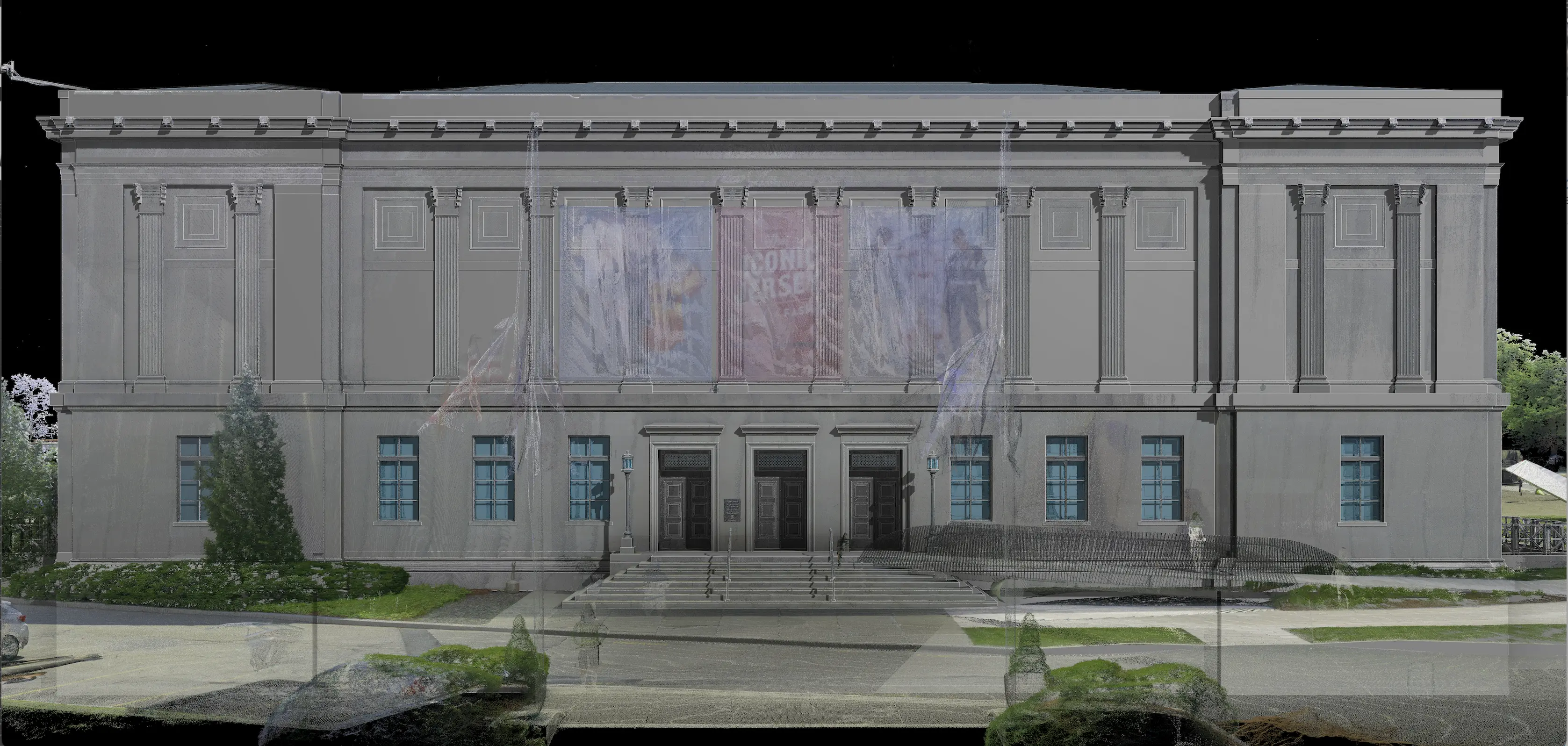
3D Laser Scanning
3D Laser scanners use LiDAR: a laser-based method of collecting highly accurate measurements. A survey-grade terrestrial 3D laser scanner lets us scan a building quickly and capture information up to one kilometer away. Other scanners use SLAM technology, which enables a user to scan a building at walking speed. This technology is essential for the collection of accurate interior and exterior information about your asset. These scanners can capture millions of data points per second, providing incredibly rich detail of every aspect of your project. This quick, safe, and non-intrusive option allows you to have exceptional situational awareness of your building. Because these tools scan 360 degrees, when scanning the exterior of a building, they scan the surrounding areas as well, giving you great contextual information about your site and adjacencies.
The amount of information gathered through the laser scanning process is impressive. This data shows the true state of warped, leaning, sagging, or twisted structures, as the 3D laser scanner measures everything within line-of-sight. After the site data is collected, the next step is to document the elements of the asset in a 3D BIM model or 2D CAD drawing.
.png)
Virtual Site Visit
To revisit the areas that were surveyed, you must be provided with access to the collected data. This technology acts like many online street-view tools that allow you to walk through the site and see the actual conditions of when the building was surveyed. You will have access to laser-accurate dimension tools to help you evaluate the conditions of your asset remotely. Teams from all over the world can now collaborate on your project and visit the site virtually without ever having to step foot on the ground. This virtual walkthrough data is typically accessed through free Windows PC-based software, but it can also be made available online to enable anyone to access this secure location from any web-enabled device.

BIM Modeling/CAD Drawings/Other Platforms
When it comes to interpreting the laser scan data and generating drawings or models from that data, it is important to consider the various ways that can be accomplished. 2D CAD drawing used to be the standard and many software platforms utilize the DWG file for this purpose. However, with the advent of BIM modeling, the primary method of generating drawings and models from scan data is to utilize software such as Autodesk Revit. Revit is widely used in the AEC industry and provides the best flexibility when working with other software.
Software alone does not guarantee a good set of drawings or BIM models. Another aspect to consider is who will be creating the BIM model. It is important to verify that the team you choose has the architectural experience and knows how buildings should be modeled to maximize the efficiency of passing on those models to the teams that will ultimately use them. Many times specific templates and standards are needed to be met for the modeling process. This is something to check to make sure that the team can accommodate those requests and deliver accordingly.
Virtual BIM Department
Architects and engineers generally have access to software such as Revit to work with the 3D information contained within the BIM model, however, this is not true for building owners. With the advance of BIM technology, it has become harder for building owners to access that data without having to purchase and maintain expensive software and dedicated employees.
The data contained in a BIM model could be very advantageous for building owners, so they can better understand their assets and make intelligent decisions for their projects. This is why building owners need to have a way to manage BIM files for their assets effectively to ensure that renovations are accurately documented in their BIM/Revit model, keeping them up to date.
Finding a team that can provide this virtual BIM model maintenance and support is crucial. This involves not only maintaining and supporting the BIM models and keeping them up to date when renovations are complete, but also hosting large datasets and providing access to the project data for contractors, architects, engineers, etc. This way, building owners can own, not only the physical building, but also an accurate digital representation for all work moving forward.
Scaling Technology...
Having the right software and tools is not enough to provide accurate existing conditions information about capital projects. Experience is required in a variety of project types in order to know how to best implement the tools and software. Depending on the needs of the project, it is important to have a team that can scale reality capture technology to get exactly what is needed at a great price.
To Reduce Your Risk
Pre-construction surveys capture the neighboring buildings prior to construction commencing to mitigate claims about the construction process damaging their building. Historically, this work has been done with photography and videos, but with 3D laser scanning, you can add dimensional data as well. Not only can you see the existing crack in a neighboring structure, but you can get measurements on it as well.
You can also use this approach to document changes to your own building over time. If a building has a known lean to it, you can return and scan it every couple of years to see if the lean is a result of historical settlement or is currently progressing.
To Reduce Time on Site
Employing 3D laser scanners with SLAM technology speeds up the data collection process and allows minimal time on-site to collect large amounts of data.
To Increase Levelness of Data
To increase the level of data, highly accurate terrestrial 3D laser scanners can be employed to produce leveled scan data for floor deformation maps and elevation information.
To Tie into Survey Control
Laser scan data can be tied into existing survey control to provide a greater level of accuracy and coordination between various consultants on a project. This is something that needs to be established before laser scanning for the best accuracy.
To Deliver a Project in Phases
For most projects, specific floor plans, square footage, and ceiling heights can be delivered relatively early on in the project. To do so, you would need to be able to identify which areas are a high priority, and then those drawings would be delivered to you first. After that, elevations, RCPs, and MEP documentation can be completed and delivered. Since the building is already scanned, no additional site work will be required to add additional drawings to the project (as long as we have access to all the spaces required).
Projects are frequently delivered in phases to allow teams to begin their work before the entire project is complete (as deadlines and project timelines are sometimes tight). To facilitate architects' work before demolition, the building can be 3d laser scanned, and minimal core and shell drawings can be provided. Once the demo is complete, we will return to the site to capture the beam and column locations and deliver updates to the architect so they can further refine their work.
Leverage Our Expertise
Existing Conditions was created to deliver high-quality as-built documentation more accurately, efficiently, and cost-effectively than anyone else in the market.
We have stayed true to our founding principles and continue to excel at leveraging reality capture technologies to deliver the most comprehensive building documentation.
Over the past 27 years, we have measured and documented 10,000 buildings spanning over 700 million square feet across the United States for architects, engineers, building owners, and real estate professionals.
When you need existing conditions drawings of your valued asset, trust the experts at Existing Conditions. Let us be your eyes in the field so that you can devote your time to what you do best. We provide professionals with situational awareness and empower them with the confidence to make smart decisions based on accurate data. Leverage our experience, equipment, and expertise. For decades, we've helped professionals in the building industry implement solutions to the hardest problems they face.
Start Accurate. Stay Accurate. Contact Existing Conditions to begin planning your capital project today.
Existing Conditions 3D Laser Scanning Services
Over the past 27 years, we have measured, documented, and modeled over 10,000 buildings spanning over 700 million square feet across the United States, establishing ourselves as an industry leader in 3D laser scanning. Architects, builders, engineers, developers, and facility managers, trust us to deliver digital representations of the as-built environment with unparalleled accuracy and efficiency. Our dedicated Project Managers provide fast and accurate 3D laser scanning services, and expert CAD and BIM technicians create custom, detailed deliverables. Our greatest reward remains delivering superior-quality scan-to-BIM work and knowing we played a vital role in our clients’ unique and historic projects.
FAQs
How Does Laser Scanning Work?
.svg)
One primary method is that a laser scanner sends light pulses at high speeds which reflect off objects and return to the scanners’ sensor. For each pulse, the distance between the scanner and object is measured by determining the elapsed time between the sent and received pulses. Each point of the scan will be converted to a pixel with a known x-, y-, and z- coordinate. Laser scans or LiDAR scans are taken in multiple positions around a site from varying viewpoints. Millions of data points are captured and processed into a point cloud, creating an accurate data set of the structure or site.
How Does Scan to BIM Aid Renovations?
Scan to BIM plays a critical role in renovations by providing accurate as-built data, point clouds, drawings and models that reflect the current state of a building. This ensures that renovation plans are based on precise data, minimizing the risk of costly errors and ensuring seamless integration with existing structures.
How Accurate is the Point Cloud and BIM Model?
Point clouds are a digital representation of spatial information, stored as a collection of points with three spatial coordinates. They are millimeter-accurate and are scanned in the level of detail required for your project. BIM model features are created to your project-specific scope, LOD specifications can vary throughout the model. By specifying scope and project details, BIM models can be customized to your project.
Related Articles