How Certain Conditions Can Impact 3D Laser Scans

.webp)
Importance of 3D Laser Scanning
Documenting a structure using 3D laser scanners allows for incomparable precision and accuracy, superior insights on the building’s layout, improved efficiency and more. Because of this, it is important to understand the conditions that make it difficult for 3D laser scanners to properly scan and document a building or area.
Conditions That Make It Difficult for 3D Laser Scanning
The way a laser scanner documents a location is by sending high speed light pulses that reflect off objects and return to the scanner’s sensor (LiDAR). Where the laser is pointed is known as its line of sight and if something interferes with that, the data received can be inaccurate or incomplete.
.webp)
Reflective Surfaces
The efficiency and accuracy of 3D laser scanners can be impacted by reflective surfaces due to the laser bouncing off of shiny objects. When the laser bounces off them, the results may be distorted by “noise,” also known as data interference, due to specular reflections from the laser or bright spots created by the reflective materials.
Standing Water
3D laser scanning water poses similar difficulties as reflective objects since the water’s surface is essentially a reflective plate. The presence of particles within the water also serves as an obstacle that will cause the laser to bounce off or scatter, once again leading to distorted or incomplete data.
Inclement Weather
Weather conditions like rain and fog can impact the ability to document reliable and accurate 3D laser scans. It is not advisable to expose the electronic scanning equipment to rain. Plus, individual water droplets can have a prismatic effect on the laser, scattering it rather than creating clean, point-to-point data capture. In foggy conditions, it is possible to still see the laser beam, however, the light will scatter due to the water molecules and make it difficult for the sensor to differentiate what is being scanned.
Overgrown Vegetation
Similarly, overgrown vegetation can block the laser’s line of sight, creating gaps in the point cloud data.
Structural Failure
Structural failures, like cracks or deformations, do not affect the process of 3D laser scanning directly since there is nothing hindering the scan like in previous examples. The challenge with regard to structural failures is analyzing the individual items within the point cloud, since these defects in the structure can change the size and shape of the objects being scanned.
Chemical Spills or Gas Leaks
The presence of gas leaks or chemical spills present many problems that can affect the laser scanning process. Beyond the safety risks involved, chemical spills and gas leaks can have a similar effect that fog does on laser scanning. The laser beam will still be visible, but vapor, fumes, or haze that can accompany a leak can lead to scattering and inaccurate results. Chemical spills can also appear shiny or reflective leading to the laser beam bouncing off the surface and producing an incomplete scan ofthe area.
Other Conditions That Can Affect 3D Scans
- Asbestos
- Lead exposure
- Steam vents
- Electrical hazards
- Fallen trees or debris
- Uneven terrain
- Extreme weather events
- Other hazardous environments that require intrinsically safe equipment
How Existing Conditions Can Help
Some buildings that we work in are in a state that could make 3D laser scanning difficult. Because of this, it is important to utilize a team like Existing Conditions with the proper training, experience, OSHA training, and PPE to capture data efficiently.
Using point cloud data, the Existing Conditions team produces 2D CAD drawings and 3D BIM models that facilitate precise system upgrades. This ensures the seamless integration of new components, reduces errors, minimizes cost, and shows the client what they need to see.
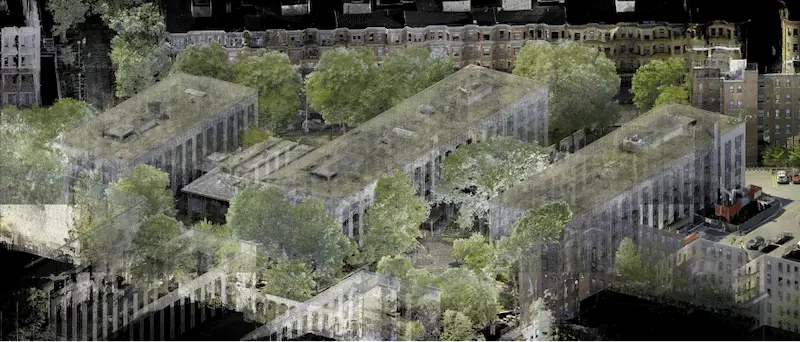
In the photos above, Existing Conditions was tasked with scanning the abandoned Foxboro Auditorium to give the client a detailed look at the structure’s current state. During that job, they encountered hazards such as a collapsing ceiling, asbestos, mold, and lead paint. With their extensive training along with a respirator to keep them safe from the harmful air quality, they documented the former auditorium’s existing conditions despite the obstacles they faced.
For comprehensive visualization and accurate documentation of your projects, trust Existing Conditions to deliver unparalleled results. Let us help you optimize your engineering solutions.
Existing Conditions 3D Laser Scanning Services
Over the past 27 years, Existing Conditions has measured, documented, and modeled over 10,000 buildings spanning over 700 million square feet across the United States, establishing ourselves as an industry leader in 3D laser scanning. And we are proud to have expanded our reach nationally by partnering with GPRS.
Architects, builders, engineers, developers, facility managers, trust us to deliver digital representations of the as-built environment with unparalleled accuracy and efficiency. Our dedicated Project Managers provide fast and accurate 3D laser scanning services, and expert CAD and BIM technicians create custom, detailed deliverables. Our greatest reward remains delivering superior-quality reality capture and scan-to BIM services, and played a vital role in helping our clients visualize what they require to complete their unique and historical projects.
FAQs
What is LiDAR?
.svg)
LiDAR, which stands for Light Detection and Ranging, is a remote sensing method used to generate precise, three-dimensional information about the shape of an object and its surface characteristics. 3D laser scanners utilize LiDAR technology to precisely capture the three-dimensional data of a structure or site. LiDAR operates by emitting light as a pulsed laser to measure distances to a target. When these laser pulses bounce back to the scanner, the distances are recorded, mapping the spatial geometry of the area. This process collects millions of measurement points, each with x, y, and z coordinates, forming what is known as a point cloud.
Why is a Point Cloud Important?
Point clouds provide powerful and dynamic information for a project. By representing spatial data as a collection of coordinates, point clouds deliver large datasets that can be mined for information. The visualization and analysis from this data is invaluable for decision making. Our Product team transforms point clouds into customized drawings and models used for visualization, analysis, design, construction, renovation, prefabrication, and facility modifications.
How Accurate is the Point Cloud and BIM Model?
Point clouds are a digital representation of spatial information, stored as a collection of points with three spatial coordinates. They are millimeter-accurate and are scanned in the level of detail required for your project. BIM model features are created to your project-specific scope, LOD specifications can vary throughout the model. By specifying scope and project details, BIM models can be customized to your project.