How Laser Scans & Data Platforms Are Used to Build Accurate 2D & 3D Maps & Models

You’re walking through a 100-year-old hospital wing – an architectural time capsule filled with stories, structure, and untapped potential.
The original plans?
Buried somewhere in a dusty basement archive, if they exist at all. Overhead, a dense web of pipes and ductwork crisscrosses the ceiling, layered from decades of upgrades, repairs, and improvisations.
Then, inspiration strikes.
You don’t just see the complexity; you see the opportunity. The chance to honor the past while designing for the future.
You bring clarity to chaos as you integrate modern systems with historic fabric, reimagining the space with confidence and purpose.
Because with the right data, every detail becomes a design decision, grounded and ready to build on.
3D Laser Scanning & Measuring Devices
At Existing Conditions, a GPRS company, we promise and deliver construction-grade accuracy because we use the most advanced scanning technologies available. Each tool in our arsenal is chosen for a specific purpose, ensuring we capture every detail, in every environment, with high precision.
Using cutting-edge tools like LiDAR, photogrammetry, and advanced visualization solutions, we create detailed as-built documentation – everything from 2D CAD drawings and 3D BIM models to mesh files and virtual site visits.
Our methodology process ensures construction-grade accuracy, helping architects avoid design conflicts, reduce RFIs, and prevent costly rework or utility strikes. Captured data is processed quickly and securely hosted on Microsoft Azure, with delivery via Media Shuttle for fast, reliable access.
Clients can simplify downloads using the Signiant app, which enables secure, high-speed file transfers. We also deliver as-builts in 2D AutoCAD, formatted to match your templates and specs, making our work as seamless and ready-to-use as possible.
Leica P-Series: Long-Range, Highest Level of Detail, Dual Axis Compensator
.webp)
Originally engineered for land surveying, the Leica P-Series ScanStations are rugged, weather-resistant 3D laser scanner designed to perform reliably in harsh construction conditions.
The scanners deliver high-density point clouds and HDR imaging at scan rates up to 1 million points per second, with effective ranges exceeding 1 kilometer. These systems integrate real-time, liquid-filled dual-axis compensators to maintain level alignment and reduce scan distortion due to movement. With 2–4 mm accuracy and the ability to tie into survey control networks, the P-Series delivers low-noise, high-fidelity data. The scanners are optimized for long-range applications requiring precise spatial documentation and photorealistic clarity.
In addition to extended range and high accuracy, the scanners incorporate a precision inclinometer that ensures accurate horizontal alignment, critical for deformation mapping and evaluating concrete surface leveling requirements.
Visit the Leica website for more information.
Leica RTC360: Real-Time 3D Laser Scanning with Automated Field Registration
.webp)
The Leica RTC360 combines a high-performance laser scanner with the Cyclone FIELD 360 mobile app for real-time capture and automatic field registration. It collects up to 2 million points per second and uses advanced HDR imaging to create colorized 3D point clouds with 2–4 mm accuracy – all in under two minutes.
Its VIS (Visual Inertial System) enables automatic, targetless registration and smooth data transfer from site to office, which cuts field time and boosts efficiency.
We’ve seen major workflow improvements, especially in fast-paced environments like healthcare and education, thanks to its ability to complete a greyscale scan in just 26 seconds, compared to three minutes with older scanners.
Visit the Leica website for more information.
Leica BLK360: Small, Lightweight Reality Capture with the Push of a Button
.webp)
Need scan data of above-ceiling spaces or tight mechanical rooms? The Leica BLK360 is a lightweight, wireless terrestrial laser scanner designed for rapid reality capture in confined or smaller environments. It collects up to 360,000 points per second and integrates panoramic HDR and thermal imaging – perfect for smaller, detail-critical environments. With a scanning range of 60 meters, it delivers 4 mm accuracy at 10 meters and 7 mm at 20 meters. A complete 360° scan cycle is completed in approximately three minutes.
Optimized for mobility and ease of use, the BLK360 is ideal smaller projects.
Visit the Leica website for more information.
NavVis VLX: Simultaneous Localization and Mapping (SLAM)
.webp)
When mobility and flexibility are key, like in multi-level buildings or tight corridors, we use the NavVis VLX. The VLX is a wearable mobile mapping system that captures survey-grade point clouds using dual 16-layer LiDAR sensors with SLAM technology. SLAM enables the device to continuously map and position itself in real time without reliance on external positioning systems – ideal for complex indoor environments.
With four high-resolution cameras capturing full 360° imagery and a built-in touchscreen for real-time feedback, field technicians can monitor data quality on the go.
Visit the NavVis website for more information.
Matterport Pro3: LiDAR-Based 3D Laser Scanning
.webp)
The Matterport blends LiDAR-based scanning with high-resolution imaging to generate accurate 3D models, point clouds, and floor plans. It captures 100,000 points per second, completing each sweep in under 20 seconds. With a 100-meter range, it delivers 20 mm accuracy within 10 meters.
Its custom 30 MP sensor and 12-element ultra-wide lens produce full-color digital twins, processed through the Matterport app and cloud platform for easy editing, collaboration, and sharing.
Matterport states that the Pro3 supports use cases in “Architecture and engineering to render large-scale projects at a higher level of precision.”
In the travel, hospitality, and retail industries, the Pro3 enables the creation of high-fidelity digital twins for large-scale indoor and outdoor environments, supporting immersive guest experiences and spatial planning.
In manufacturing, the Pro3 facilitates the management and optimization of complex industrial facilities by capturing long-range spatial data essential for layout planning, equipment tracking, and operational efficiency.
Visit the Matterport website for more information.
Matterport Pro2: Rectified Photogrammetry
.webp)
Photogrammetry reconstructs spatial environments using overlapping photographic imagery. When rectified, these images can be compiled into orthomosaic visuals suitable for scaled documentation. High-resolution image capture from multiple angles is essential to ensure geometric accuracy. The Matterport Pro2 is one of the tools we use to generate these datasets, supporting both orthographic outputs and immersive virtual walkthroughs.
In commercial real estate, Matterport enables more efficient management of office spaces because it supports accurate space planning, leasing visualization, and ongoing maintenance workflows.
For construction, Matterport allows teams to document site conditions and design changes quickly and non-intrusively, minimizing disruption to active job sites while maintaining an accurate record of progress.
Matterport Pro2: Imaging and Interactive Tours
The Matterport Pro2 is a 134.2 MP 3D camera system designed for rough measurements and visualization. It delivers dimensional accuracy within 3.5 cm (1% of total distance) and completes a full 360° scan in approximately 20 seconds. The platform supports the creation of interactive walkthroughs, schematic maps, and high-resolution 2D stills.
According to Matterport, residential real estate professionals use it to accelerate listings and sales with high-quality marketing visuals.
How We Use Data Platforms in 3D Scanning, Photogrammetry, and Modeling
At Existing Conditions, 3D laser scanning is a core method we use to help clients Visualize The Built World® with precision. Our Mapping & Modeling Team specializes in extracting, analyzing, and delivering point cloud data in multiple formats to support AEC workflows. Whether you're coordinating design intent, verifying as-builts, or managing construction progress, we provide the tools and data to streamline your process.
We utilize a range of industry-leading platforms to manage scan-to-BIM workflows and ensure seamless collaboration across project teams. Below are the primary platforms we use to deliver accurate, accessible, and actionable spatial data.
TruView
.webp)
Leica TruView makes it easy to explore and share point cloud data and virtual walkthroughs – right from your Windows PC. Offered free by Leica, TruView comes in two flexible formats: a portable version that runs directly from a USB drive with no installation required, and a standard desktop version for full integration. Both options are optimized for performance, provided your system meets the necessary hardware and graphics requirements.
TruView uses the efficient LGS/LGSX file format, which compresses large datasets into a single, streamlined file. This format combines imagery, dimensional data, and point cloud information to make it simple to download, share, and collaborate.
At Existing Conditions, we include LGS/LGSX files with every Leica 3D laser scanning project. These files are hosted at no cost in your Project Delivery folder and are ready to download or share with your team – no extra steps required.
Matterport
.webp)
Matterport is a widely adopted 3D data platform used to capture, store, and manage digital twins of physical spaces. The cloud-based system supports collaboration and customization, which include metadata tags, editing tools, and export of modeling files. A separate login is required to access the Matterport cloud environment.
Visit the Matterport website for more information.
Autodesk BIM 360
.webp)
BIM 360 is Autodesk’s cloud-based project delivery platform for the AEC industry. It connects all stakeholders across the project lifecycle, from design and coordination to construction and handover. BIM 360 includes modular tools like Docs, Build, Design, Coordinate, Layout, Plan, and Ops, which enable real-time collaboration and data-driven decision-making.
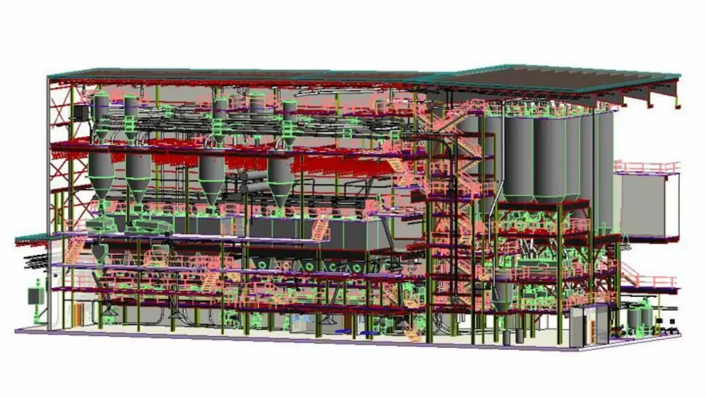
Our Reality Capture team uses a strategic blend of high-resolution photogrammetry and 3D laser scanning to deliver construction-grade spatial data that empowers informed design decisions. Our equipment, platforms, and methodologies are carefully selected to meet the demands of complex architectural environments, ensuring every scan is highly accurate, accessible, and actionable.
High quality, up-to-date documentation is the foundation for easy coordination, risk mitigation, and cost control. Inaccurate data leads to delays, rework, and budget overruns. Our approach is built to prevent that.
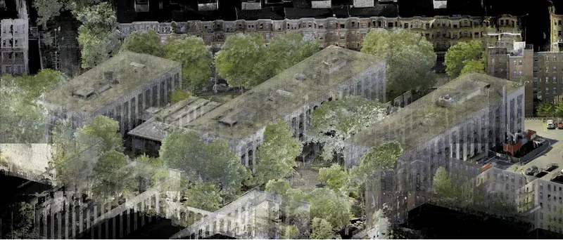
Over the past 27 years, Existing Conditions has measured, documented, and modeled over 10,000 buildings spanning over 700 million square feet across the United States, establishing ourselves as an industry leader in 3D laser scanning. Architects, builders, engineers, developers, facility managers, trust us to deliver digital representations of the as-built environment with unparalleled accuracy and efficiency. Our services, including 3D laser scanning, 3D photogrammetry, and BIM modeling, Intelligently Visualize The Built World® to enable architects to make informed design decisions based on the most accurate data available.
FAQs
How Does Laser Scanning Work?
.svg)
One primary method is that a laser scanner sends light pulses at high speeds which reflect off objects and return to the scanners’ sensor. For each pulse, the distance between the scanner and object is measured by determining the elapsed time between the sent and received pulses. Each point of the scan will be converted to a pixel with a known x-, y-, and z- coordinate. Laser scans or LiDAR scans are taken in multiple positions around a site from varying viewpoints. Millions of data points are captured and processed into a point cloud, creating an accurate data set of the structure or site.
Why are Precise Measurements Important in the Building Industry?
Precise measurements are crucial for accurate decision-making and project success. Being the best as-built survey company in the industry, we know that without precise information, the decisions made regarding a project lose accuracy, jeopardizing the quality of the project as a whole. At Existing Conditions, we understand the significance of accurate data, which is why we specialize in providing the best building industry professionals with reliable as-built drawings and existing condition surveys. Our meticulous approach ensures that you have a clear understanding of your building's existing conditions, empowering you to make informed decisions.
What are the Benefits of 3D Laser Scanning?
3D laser scanning captures millions of 3D data points per second for each scan location, providing incredibly rich data of a building or project site. Sites are captured in high detail the first time, eliminating disruption and the need for return visits. Datasets are dimensionally accurate, measurable and shareable, expediting project planning and execution. Accurate design plans are produced from the start expediting field work and reducing change orders, delays and costs. Communication is improved, teams can discuss plans while each has access to the same information, creating a more dynamic working environment.