What You Need to Know About Color vs. Greyscale in 3D Laser Scanning


At Existing Conditions, a GPRS company, we provide reality capture services to deliver accurate, reliable as-built documentation. One key aspect of this process is how point cloud data is visualized – either in greyscale, intensity, or full color, also known as RGB, which stands for red green and blue. Understanding the difference helps architects make informed decisions during design and renovation.
Greyscale 3D Laser Scanning
Greyscale point clouds are based on the intensity of the laser return signal. Capturing point cloud data in this way does not require ambient light, making it ideal for 3D laser scanning in dark or poorly lit environments. The result is a highly accurate dataset that captures geometry and surface reflectivity but without color information.
This type of scan is beneficial in environments where lighting cannot be controlled, such as basements, tunnels, or mechanical spaces. Despite the lack of color, intensity scans still provide a wealth of spatial data that can be used for modeling and measurement.
.webp)
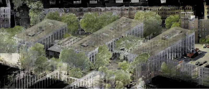
Color 3D Laser Scanning
Some 3D laser scanners are equipped with digital cameras. After the initial 3D laser scan is complete, the scanner captures hundreds of color pictures. These are stitched together and mapped onto the point cloud, producing a colorized 3D Revit model. This process requires adequate lighting to ensure accurate color representation.
Color 3D point clouds combine the geometric precision of laser scanning with the visual benefits of a photo. The result is a photorealistic point cloud that enhances understanding and communication across project teams.
.webp)
.webp)
Benefits of Color Reality Capture Data:
.webp)
Improved Spatial Awareness
Colorized point clouds make it easier to navigate and understand complex environments. This is especially helpful in mechanical rooms, utility corridors, and other dense spaces where orientation can be challenging.
Better Identification of Systems
In many facilities, pipes transporting gases, liquids, or chemicals are color-coded to ensure safety and compliance. Color 3D laser scans allow architects and engineers to trace systems more easily and read labels that may be difficult to distinguish in greyscale. This is critical when working with gas, water, or chemical lines.
Material and Texture Recognition
Color 3D laser scanning captures real-world textures and finishes. This is valuable for creating detailed 3D mesh models used in virtual reality (VR), augmented reality (AR), and mixed-reality applications. These models support design visualization, clash detection, and stakeholder presentations.
User-Friendly Deliverables
Platforms like TruView, JetStream, BubbleView, and SiteMap®, allow clients to explore the 3D laser scan data in full color through a browser – no software installation required. These tools offer 360° navigation, HDR imagery, and intuitive interaction with the point cloud, making it easier for clients to understand the space.
Virtual Design Planning
Color laser scanning provides detailed point cloud data that serves as a powerful tool for virtual design planning. This data enables architects, engineers, and contractors to visualize complex environments like mechanical rooms in a digital format. It supports the accurate design of new systems, like piping layouts, and ensures precise measurements when retrofitting existing spaces, which reduces the risk of errors and rework.
Why Color Data Matters in As-Built Documentation
While greyscale 3D laser scanning remains effective in low-light conditions, color laser scanning offers significant advantages in visualization and identification. For architects working on complex renovations or high-detail projects, colorized point clouds provide a clearer, more intuitive understanding of existing conditions.
Want to see how color scanning can support your next project? Contact us to learn more.
FAQs
Why Would An Architect Use 3D Laser Scanning?
.svg)
An architect would use 3D laser scanning services to accurately capture the existing conditions of a building in a point cloud for design and renovation projects. From the point cloud, 2D CAD drawings and a 3D BIM model can be generated to access precise layout and measurements, visualize design changes, and identify potential issues, reducing the risk of errors, ultimately saving time and cost on the project.
Why is a Point Cloud Important?
Point clouds provide powerful and dynamic information for a project. By representing spatial data as a collection of coordinates, point clouds deliver large datasets that can be mined for information. The visualization and analysis from this data is invaluable for decision making. Our Product team transforms point clouds into customized drawings and models used for visualization, analysis, design, construction, renovation, prefabrication, and facility modifications.
How Does Laser Scanning Work?
One primary method is that a laser scanner sends light pulses at high speeds which reflect off objects and return to the scanners’ sensor. For each pulse, the distance between the scanner and object is measured by determining the elapsed time between the sent and received pulses. Each point of the scan will be converted to a pixel with a known x-, y-, and z- coordinate. Laser scans or LiDAR scans are taken in multiple positions around a site from varying viewpoints. Millions of data points are captured and processed into a point cloud, creating an accurate data set of the structure or site.