Which Reality Capture Tool Fits Your Project: LiDAR or Photogrammetry?


If you’re considering reality capture services for your next project, you’ll encounter the terms LiDAR and 3D photogrammetry.
Both methods generate spatial data and digital models, but they differ in technical features, strengths, and best uses. Knowing these differences helps you choose the best solution for your project's goals and deliverables.
What Is LiDAR?
LiDAR, short for “Light Detection and Ranging,” is a remote sensing method that uses pulsed laser beams to measure distances to a target. The sensor emits ultraviolet and/or near-infrared light and calculates the time it takes for each pulse to return. This time-of-flight data is used to generate an accurate 3D representation of the scanned environment.
Because LiDAR depends on line-of-sight, you need multiple scan positions to capture an object or area.

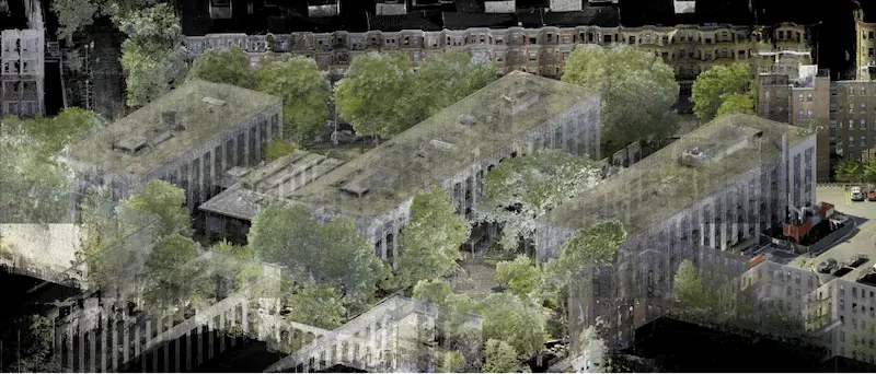
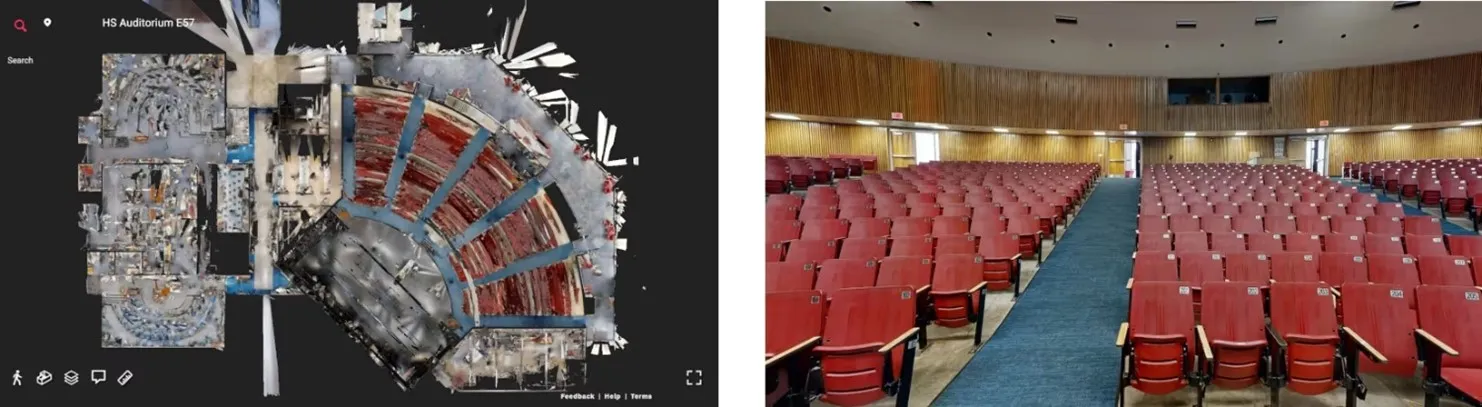
Once scanning is complete, a point cloud is then created. A point cloud provides powerful and dynamic information for a project. These point clouds serve as the foundation for creating 2D CAD drawings and 3D BIM models.
Our Mapping & Modeling Team transforms point cloud data into deliverables such as:
- Site plans
- Floor plans
- Exterior elevations
- Isometric drawings
- Reflected ceiling plans
Existing Conditions also provides 3D modeling and scan-to-BIM services. These help with space planning, prefabrication, clash detection, and design.
LiDAR scanners are classified into two categories:
- Airborne LiDAR: Mounted on drones or aircraft, suitable for large-scale or inaccessible areas
- Terrestrial LiDAR: Stationary scanners used for detailed architectural and structural documentation
Airborne LiDAR scanners can ensure positional accuracy in vast, dangerous, or hard-to-reach areas.
Companies have also incorporated LiDAR technology into consumer electronics. For example, Apple's recent iPhone models have LiDAR sensors. These sensors boost augmented reality (AR) experiences and improve camera depth perception.
LiDAR services and deliverables are ideal for construction and architectural projects. Accurate point cloud data from LiDAR 3D scans helps building industry professionals keep projects on schedule, within budget, and safe.
What Is Photogrammetry?
Photogrammetry is a technique that uses photographic images. They reconstruct 3D models of physical environments. Photogrammetry makes a digital model of a site or structure. It does this by taking high-resolution images from different angles and stitching them together.
Like LiDAR, photogrammetry can be performed using aerial or terrestrial technologies:
- Aerial photogrammetry: Utilizes drones or aircraft to capture overhead imagery
- Terrestrial photogrammetry: Involves ground-based cameras capturing images from a fixed position
Existing Conditions incorporates photogrammetry into our reality capture services through products which include TruView, WalkThru 3D, FLRPLN, and ProCap. These tools help create digital twins, virtual walkthroughs, and floor plans. They also capture our 99.8% accurate field markings.
Photogrammetry outputs include:
- Digital twins
- 2D CAD plan views
- Digital terrain models
- Interactive virtual tours
These deliverables are great for visual documentation, facility management, and site analysis. They give you a complete view of the environment, so you don’t need to be on site.
What Are the Similarities and Differences Between LiDAR and Photogrammetry?
Measurement Accuracy
LiDAR laser scanners are designed to capture detailed spatial data. They achieve 2-4 mm accuracy at distances of up to 60 meters and can capture 2 million data points per second. This is the preferred technology for architecture and construction. Being off by an inch or two can make a big difference.
Photogrammetry, on the other hand, uses overlapping rectified photos. It emphasizes detailed images instead of precise measurements.
Color Images
For projects requiring color representation, photogrammetry is the typical choice. By default, photogrammetric outputs are in full color. LiDAR, in contrast, creates greyscale point clouds unless the field technician collects RGB information. Colorized LiDAR scans need more processing time, and we recommend that you plan them in advance. They involve overlaying laser point clouds with photographic data to assign color values.
You can learn more about greyscale versus 3D laser scanning in this article.
Environmental Adaptability
LiDAR’s ability to operate in low-light or completely dark environments is a significant advantage. Since LiDAR does not depend on ambient light, it is well-suited for subterranean or poorly lit environments. Some examples of this are underground tunnels or caves. Photogrammetry uses images, so adequate lighting is key for accurate scans. In dark places, extra lights may be necessary.
Deliverables
Despite these differences, both technologies can produce similar deliverables. These include 3D models, point clouds, and 2D CAD drawings.
Aerial platforms or terrestrial setups can deploy both LiDAR and photogrammetry.
Workflow Integration and Professional Execution
Each technology supports important phases of the AEC lifecycle. They include planning, design, construction, and facility management. They cut down on repeated site visits. This boosts collaboration, improves data accuracy, and makes workflows more efficient.
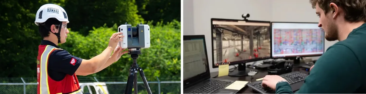
You might invest thousands in a new laser scanner, but without the right skills and experience, accuracy will be out of reach.
To receive high-quality deliverables, it’s key to collaborate with experts. This includes our Reality Capture Project Managers. They have the technical expertise and training required to operate these tools.
Ready to determine the best reality capture solution for your next project? Explore the full article on LiDAR vs. 3D Photogrammetry, including use cases, deliverables, and expert insights to help you make an informed decision.
Over the past 27 years, Existing Conditions has measured, documented, and modeled over 10,000 buildings spanning over 700 million square feet across the United States, establishing ourselves as an industry leader in reality capture. Architects, builders, engineers, developers, and facility managers trust us to deliver digital representations of the as-built environment with unparalleled accuracy and efficiency. Our services, including 3D laser scanning, 3D photogrammetry, and BIM modeling, Visualize The Built World® to enable architects to make informed design decisions based on the most accurate data available.
What can we help you visualize?
FAQs
What is LiDAR?
.svg)
LiDAR, which stands for Light Detection and Ranging, is a remote sensing method used to generate precise, three-dimensional information about the shape of an object and its surface characteristics. 3D laser scanners utilize LiDAR technology to precisely capture the three-dimensional data of a structure or site. LiDAR operates by emitting light as a pulsed laser to measure distances to a target. When these laser pulses bounce back to the scanner, the distances are recorded, mapping the spatial geometry of the area. This process collects millions of measurement points, each with x, y, and z coordinates, forming what is known as a point cloud.
How Does Laser Scanning Work?
One primary method is that a laser scanner sends light pulses at high speeds which reflect off objects and return to the scanners’ sensor. For each pulse, the distance between the scanner and object is measured by determining the elapsed time between the sent and received pulses. Each point of the scan will be converted to a pixel with a known x-, y-, and z- coordinate. Laser scans or LiDAR scans are taken in multiple positions around a site from varying viewpoints. Millions of data points are captured and processed into a point cloud, creating an accurate data set of the structure or site.
What is Terrestrial Laser Scanning?
Terrestrial laser scanning uses a tripod-based laser scanner to capture highly accurate data on buildings, structures, equipment, utilities, and processes to plan for construction, renovation, and modifications. Terrestrial laser scanning is a non-contact and non-destructive technology that digitally captures the shape of physical objects using laser light. In addition, it can capture digital photos of the same area being scanned, which can be used to create photorealistic 3D models.