How Existing Conditions Manages Large Point Cloud Sets

Today, many AEC professionals carry out projects that still rely on outdated drawings, manual measurements, and incomplete data. While these traditional methods were a norm in the industry for decades, they often introduce unknowns that can lead to misaligned models, rework, and coordination challenges. Without a verified understanding of existing site conditions, project teams are left to make critical decisions with limited situational awareness of their building or structure.
Imagine a workflow where every decision is based on construction-grade data. Because high-resolution point clouds capture every surface, structure, hard-to-reach area, and spatial relationship, project teams can visualize the built environment exactly as it exists. This reliable data empowers architects, engineers, and contractors to collaborate with confidence, reduce uncertainty, and meet project deadlines. It transforms how the building industry approaches design and construction from the very beginning.
.webp)
Why Use Point Cloud Data for Design and Construction Planning?
Reality capture technologies like LiDAR and photogrammetry capture millions of data points to generate a point cloud that accurately represents existing site conditions. This true-to-life digital model provides precise documentation of structural geometry, spatial data, and surface details critical for informed designs and construction planning. Point cloud data used in project workflows helps teams reduce risk, improve coordination, reduce costly clashes, and ensure alignment with the existing building or structure.
What is a Point Cloud?
According to Autodesk, “A point cloud is a set of data points in a three-dimensional coordinate system. Each point in the cloud contains multiple measurements, including color and luminance, as well as its position along the XYZ axes.”
Existing Conditions defines a point cloud as a critical aspect of reality capture, providing a precise and detailed snapshot of the spatial conditions of a building or space. These point clouds consist of millions of individual data points, each accurately positioned in X, Y, and Z coordinates, and often accompanied by greyscale or color information.
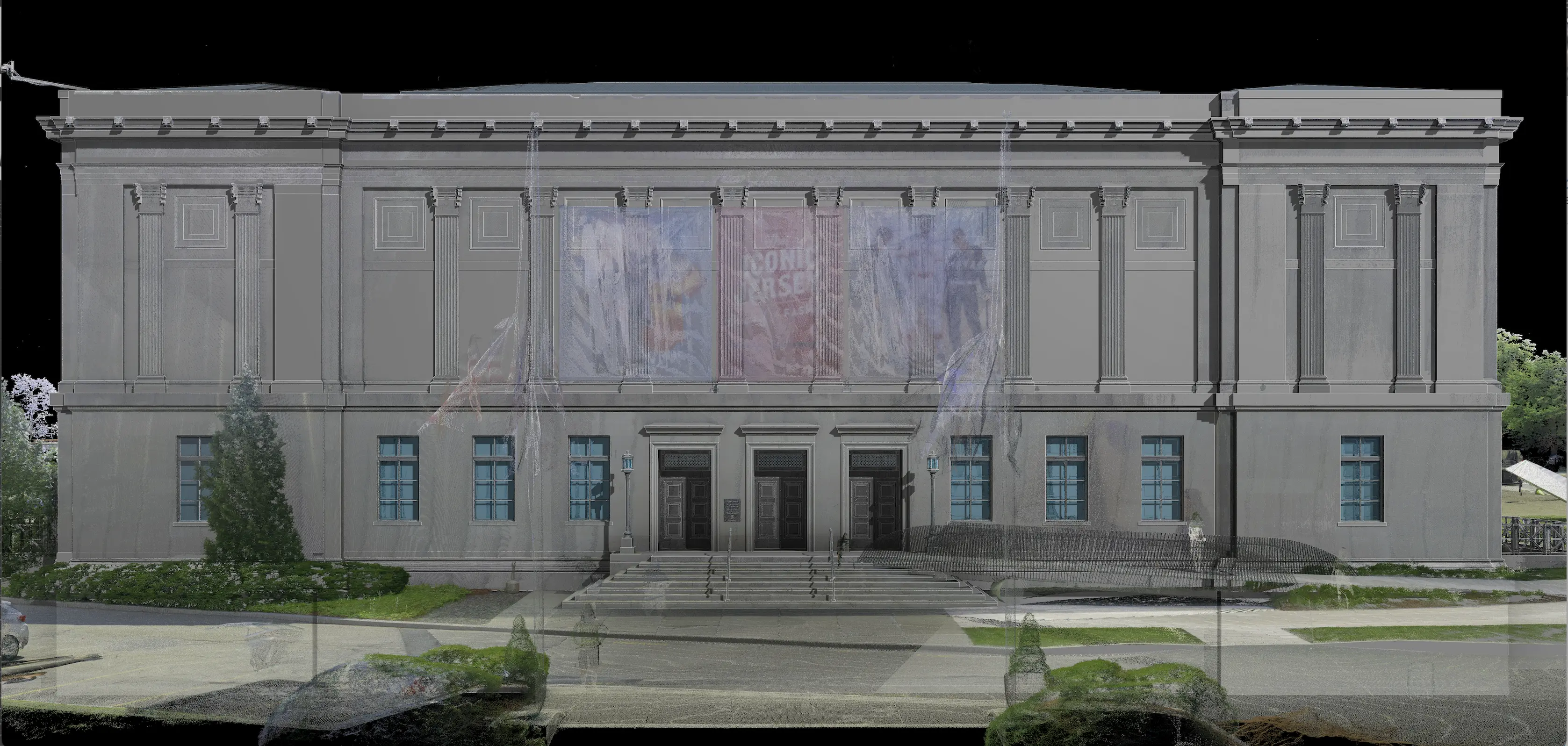
To document buildings or structures, Existing Conditions’ Project Managers position the laser scanners at different locations across a site to capture individual scans. Each scan produces millions of XYZ coordinates, which record surfaces, color, and texture that is highly precise, typically within 2–4 mm of accuracy. The end result is a comprehensive and photorealistic digital representation of the built environment.
The density of a point cloud depends on scan resolution, site complexity, and coverage area. For instance, scanning a large facility may generate billions of points. Scans that are highly dense produce more detailed points and significantly larger point cloud file sizes.
Projects often involve hundreds of scans, which generate datasets that can exceed a terabyte, and therefore require rigorous workflows for registration, storage, and processing.
.webp)
Why Does Point Cloud Registration Matter?
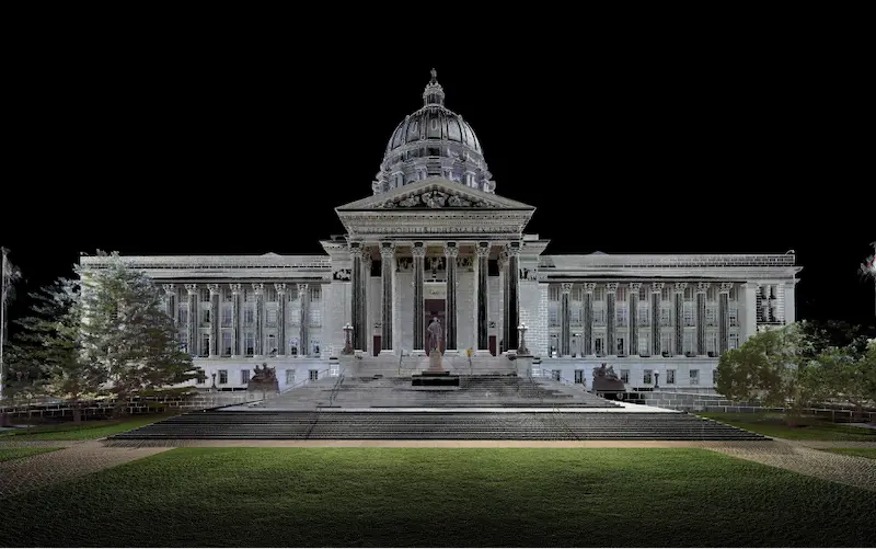
Registering a 3D laser scan point cloud requires the alignment of multiple scans, captured from different positions across the same building or structure, into a singular and accurate dataset. This process is important for documenting existing conditions because it ensures that the resulting point cloud reflects the true as-built conditions of the environment. Getting the registration completed correctly ensures the creation of precise measurements, models, and drawings.
Existing Condition’s Project Managers are trained to capture laser scan data in a way that supports tight and seamless registration. They position scanners at multiple locations across the site to make sure there is adequate overlap between scans.
The Mapping & Modeling Team consolidates individual scans into one, singular point cloud by aligning and merging the data. Raw scan files are converted into Autodesk ReCap formats, including RCS (scan files) and RCP (project files).
Each dataset undergoes a thorough quality control process that includes noise removal, coordinate system alignment, and verification of accurate registration. The team inspects for misalignments or inconsistencies and ensures that all scans are precisely registered, resulting in reliable measurements to create accurate 2D drawings and BIM models.
The Existing Conditions team has extensive experience registering point cloud datasets of all scales, and our Project Managers scan over 50 million square feet annually. Projects have included thousands of individual scans across complex sites that span hundreds of acres and feature infrastructure with miles of piping. Regardless of project size or complexity, the team delivers precisely registered point clouds that serve as the foundation for accurate 2D as-built documentation and 3D BIM modeling.
How Does Existing Conditions Manage Large Point Cloud Data Sets?
Once a point cloud is fully registered, it can be exported for client use in analysis, visualization, or processing. In collaboration with the Existing Conditions Mapping & Modeling Team, customized strategies are implemented to manage dense point cloud datasets effectively among the architecture, engineering, and construction industries.
- Data Storage: Clients are recommended to utilize a storage solution capable of handling highly dense datasets. Options include cloud-based platforms, network-attached storage (NAS), or dedicated storage servers.
- Data Compression: We can use compression techniques that are applied to reduce file sizes without compromising data quality. Unified RCS files can be produced, or large projects can be segmented into multiple RCS files one by one.
- Data Streaming: To optimize performance, we recommend streaming methods, which allow point cloud data to be loaded in increments to reduce memory load and improve responsiveness during processing.
- Level of Detail (LOD): Our Mapping & Modeling Team can create multiple levels of detail within the dataset to prioritize higher levels of detail in critical areas while we reduce density in less important areas. This approach still maintains essential information while minimizing the overall file size.
- Data Filtering: Filtering techniques are used to eliminate redundant or irrelevant points from the dataset. In Autodesk ReCap, users can adjust point spacing during unification or apply decimation to reduce resolution by excluding points in rows, columns, or both. Noise and extra data, which include elements outside the area of importance, can be cropped or removed to dilute the dataset. These strategies ensure that point cloud data remains manageable, accurate, and optimized for modeling and documentation.
.webp)
How Is Point Cloud Data Used in AEC Projects?
Point cloud data is now a core component of pre-design planning across the architecture, engineering, and construction industries. A detailed digital dataset of existing site conditions enables project teams to make informed decisions using accurate, real-time information, without having to rely on manual, time-consuming measurements.
These datasets are used to generate 2D CAD drawings and 3D BIM models to support efficient planning, design, construction, and long-term asset management.
Existing Conditions delivers high-resolution point clouds, as-built documentation, and model-ready files to support even the most complex scopes of work. These deliverables help clients visualize, coordinate, and execute projects with confidence.
Architects, builders, engineers, developers, and facility managers, trust us to deliver digital representations of the as-built environment with unparalleled accuracy and efficiency. Our services, including 3D laser scanning and BIM modeling, enable architects to make informed design decisions based on the most accurate data available.
FAQs
What is a Point Cloud?
.svg)
A point cloud is a collection of data points in a 3D coordinate system, where each point represents a specific location on the surface of an object, essentially creating a digital 3D representation of that object; typically generated using a 3D laser scanner or 3D photogrammetry, with each point containing its own X, Y, and Z coordinate.
Why is a Point Cloud Important?
Point clouds provide powerful and dynamic information for a project. By representing spatial data as a collection of coordinates, point clouds deliver large datasets that can be mined for information. The visualization and analysis from this data is invaluable for decision making. Our Product team transforms point clouds into customized drawings and models used for visualization, analysis, design, construction, renovation, prefabrication, and facility modifications.
How Accurate is the Point Cloud and BIM Model?
Point clouds are a digital representation of spatial information, stored as a collection of points with three spatial coordinates. They are millimeter-accurate and are scanned in the level of detail required for your project. BIM model features are created to your project-specific scope, LOD specifications can vary throughout the model. By specifying scope and project details, BIM models can be customized to your project.
Related Articles